You are here: Home > Network List > TA - USArray Transportable Network (new EarthScope stations) Stations List
> Station V22A San Miguel Ranch, Cuba, NM, USA > Earthquake Result Viewer
V22A San Miguel Ranch, Cuba, NM, USA - Earthquake Result Viewer
| Earthquake location: |
Tonga Islands |
| Earthquake latitude/longitude: |
-15.1/-173.5 |
| Earthquake time(UTC): |
2008/08/19 (232) 16:30:13 GMT |
| Earthquake Depth: |
8.0 km |
| Earthquake Magnitude: |
5.6 MB, 5.9 MS, 6.1 MW, 6.0 MW |
| Earthquake Catalog/Contributor: |
WHDF/NEIC |
|
| Network: |
TA USArray Transportable Network (new EarthScope stations) |
| Station: |
V22A San Miguel Ranch, Cuba, NM, USA |
| Lat/Lon: |
35.91 N/106.91 W |
| Elevation: |
2164 m |
|
| Distance: |
80.7 deg |
| Az: |
48.993 deg |
| Baz: |
243.894 deg |
| Ray Param: |
0.04807013 |
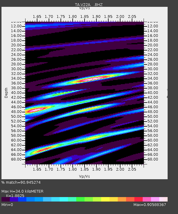
| Estimated Moho Depth: |
34.0 km |
| Estimated Crust Vp/Vs: |
1.88 |
| Assumed Crust Vp: |
6.502 km/s |
| Estimated Crust Vs: |
3.454 km/s |
| Estimated Crust Poisson's Ratio: |
0.30 |
|
| Radial Match: |
90.945274 % |
| Radial Bump: |
400 |
| Transverse Match: |
71.084175 % |
| Transverse Bump: |
400 |
| SOD ConfigId: |
2504 |
| Insert Time: |
2010-03-06 07:53:56.797 +0000 |
| GWidth: |
2.5 |
| Max Bumps: |
400 |
| Tol: |
0.001 |
|
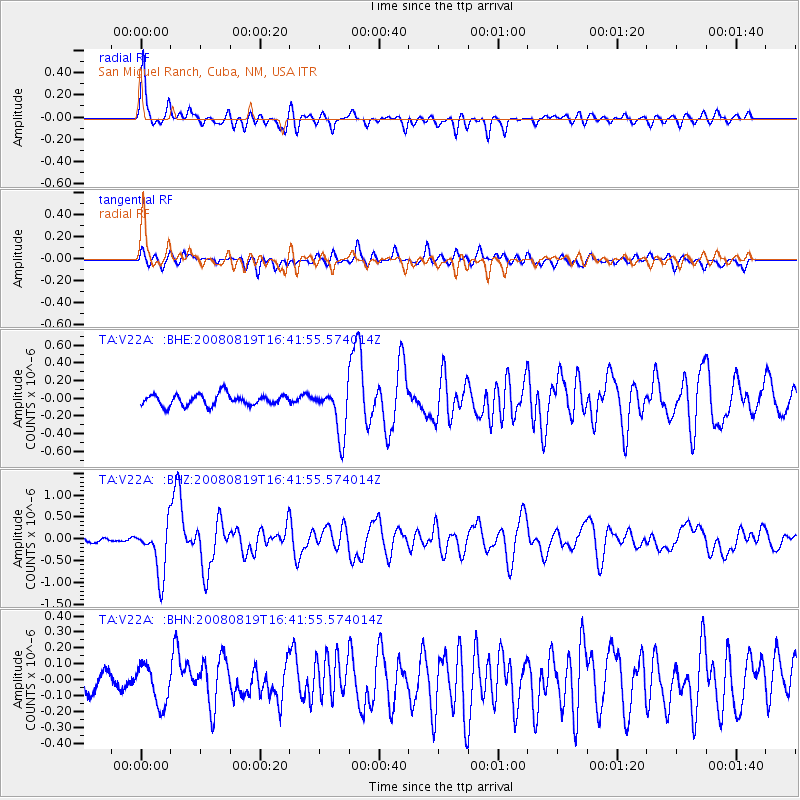
Signal To Noise
| Channel | StoN | STA | LTA |
| TA:V22A: :BHZ:20080819T16:41:55.574014Z | 10.452284 | 5.876602E-7 | 5.6223143E-8 |
| TA:V22A: :BHN:20080819T16:41:55.574014Z | 1.6871578 | 1.2226442E-7 | 7.246769E-8 |
| TA:V22A: :BHE:20080819T16:41:55.574014Z | 4.305518 | 2.7266174E-7 | 6.332844E-8 |
| Arrivals |
| Ps | 4.7 SECOND |
| PpPs | 15 SECOND |
| PsPs/PpSs | 19 SECOND |


