You are here: Home > Network List > CA - Catalan Seismic Network Stations List
> Station CGAR Garraf > Earthquake Result Viewer
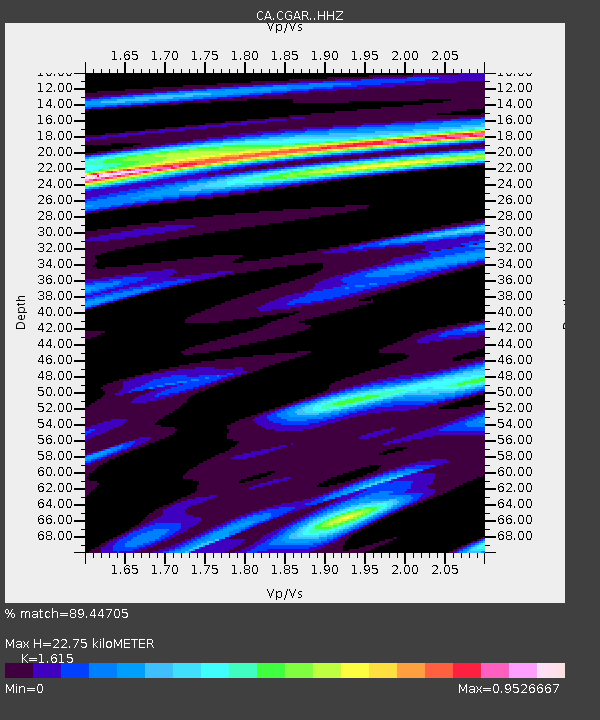
CGAR Garraf - Earthquake Result Viewer
| Earthquake location: |
Near Coast Of Peru |
| Earthquake latitude/longitude: |
-15.8/-74.7 |
| Earthquake time(UTC): |
2018/01/14 (014) 09:18:45 GMT |
| Earthquake Depth: |
36 km |
| Earthquake Magnitude: |
7.1 mww |
| Earthquake Catalog/Contributor: |
NEIC PDE/us |
|
| Network: |
CA Catalan Seismic Network |
| Station: |
CGAR Garraf |
| Lat/Lon: |
41.29 N/1.91 E |
| Elevation: |
584 m |
|
| Distance: |
90.6 deg |
| Az: |
47.158 deg |
| Baz: |
249.532 deg |
| Ray Param: |
0.041658305 |
| Estimated Moho Depth: |
22.75 km |
| Estimated Crust Vp/Vs: |
1.62 |
| Assumed Crust Vp: |
6.391 km/s |
| Estimated Crust Vs: |
3.957 km/s |
| Estimated Crust Poisson's Ratio: |
0.19 |
|
| Radial Match: |
89.44705 % |
| Radial Bump: |
400 |
| Transverse Match: |
69.93045 % |
| Transverse Bump: |
400 |
| SOD ConfigId: |
13570011 |
| Insert Time: |
2019-04-29 13:35:10.625 +0000 |
| GWidth: |
2.5 |
| Max Bumps: |
400 |
| Tol: |
0.001 |
|

Signal To Noise
| Channel | StoN | STA | LTA |
| CA:CGAR: :HHZ:20180114T09:31:12.247002Z | 14.769391 | 7.3625065E-6 | 4.984976E-7 |
| CA:CGAR: :HHN:20180114T09:31:12.247002Z | 2.4697473 | 1.1615962E-6 | 4.7032995E-7 |
| CA:CGAR: :HHE:20180114T09:31:12.247002Z | 4.8236113 | 2.6228367E-6 | 5.437496E-7 |
| Arrivals |
| Ps | 2.2 SECOND |
| PpPs | 9.1 SECOND |
| PsPs/PpSs | 11 SECOND |


