You are here: Home > Network List > GS - US Geological Survey Networks Stations List
> Station OK029 Liberty Lake, Oklahoma, USA > Earthquake Result Viewer
OK029 Liberty Lake, Oklahoma, USA - Earthquake Result Viewer
| Earthquake location: |
Near Coast Of Ecuador |
| Earthquake latitude/longitude: |
0.4/-79.9 |
| Earthquake time(UTC): |
2016/04/16 (107) 23:58:37 GMT |
| Earthquake Depth: |
19 km |
| Earthquake Magnitude: |
7.8 MWW, 7.4 MI |
| Earthquake Catalog/Contributor: |
NEIC PDE/NEIC COMCAT |
|
| Network: |
GS US Geological Survey Networks |
| Station: |
OK029 Liberty Lake, Oklahoma, USA |
| Lat/Lon: |
35.80 N/97.45 W |
| Elevation: |
333 m |
|
| Distance: |
38.8 deg |
| Az: |
337.033 deg |
| Baz: |
151.317 deg |
| Ray Param: |
0.07531164 |
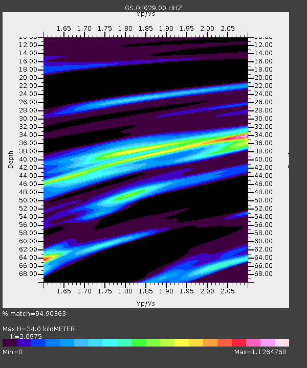
| Estimated Moho Depth: |
34.0 km |
| Estimated Crust Vp/Vs: |
2.10 |
| Assumed Crust Vp: |
6.426 km/s |
| Estimated Crust Vs: |
3.064 km/s |
| Estimated Crust Poisson's Ratio: |
0.35 |
|
| Radial Match: |
94.90363 % |
| Radial Bump: |
328 |
| Transverse Match: |
89.548615 % |
| Transverse Bump: |
400 |
| SOD ConfigId: |
1475611 |
| Insert Time: |
2016-05-01 00:04:39.239 +0000 |
| GWidth: |
2.5 |
| Max Bumps: |
400 |
| Tol: |
0.001 |
|

Signal To Noise
| Channel | StoN | STA | LTA |
| GS:OK029:00:HHZ:20160417T00:05:30.194001Z | 14.847893 | 3.446595E-6 | 2.3212688E-7 |
| GS:OK029:00:HH1:20160417T00:05:30.194001Z | 10.1714735 | 1.7518512E-6 | 1.7223181E-7 |
| GS:OK029:00:HH2:20160417T00:05:30.194001Z | 6.2861958 | 2.0338716E-6 | 3.2354572E-7 |
| Arrivals |
| Ps | 6.2 SECOND |
| PpPs | 15 SECOND |
| PsPs/PpSs | 22 SECOND |


