You are here: Home > Network List > CA - Catalan Seismic Network Stations List
> Station CLLI Llivia > Earthquake Result Viewer
CLLI Llivia - Earthquake Result Viewer
| Earthquake location: |
Near Coast Of Peru |
| Earthquake latitude/longitude: |
-15.8/-74.7 |
| Earthquake time(UTC): |
2018/01/14 (014) 09:18:45 GMT |
| Earthquake Depth: |
36 km |
| Earthquake Magnitude: |
7.1 mww |
| Earthquake Catalog/Contributor: |
NEIC PDE/us |
|
| Network: |
CA Catalan Seismic Network |
| Station: |
CLLI Llivia |
| Lat/Lon: |
42.48 N/1.97 E |
| Elevation: |
1413 m |
|
| Distance: |
91.0 deg |
| Az: |
46.064 deg |
| Baz: |
249.587 deg |
| Ray Param: |
0.04162586 |
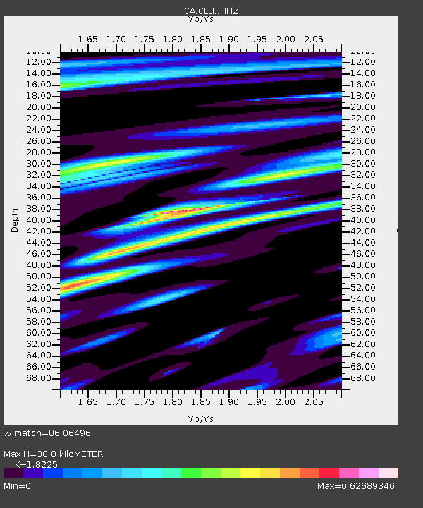
| Estimated Moho Depth: |
38.0 km |
| Estimated Crust Vp/Vs: |
1.82 |
| Assumed Crust Vp: |
6.416 km/s |
| Estimated Crust Vs: |
3.52 km/s |
| Estimated Crust Poisson's Ratio: |
0.28 |
|
| Radial Match: |
86.06496 % |
| Radial Bump: |
400 |
| Transverse Match: |
83.663994 % |
| Transverse Bump: |
400 |
| SOD ConfigId: |
13570011 |
| Insert Time: |
2019-04-29 13:35:11.160 +0000 |
| GWidth: |
2.5 |
| Max Bumps: |
400 |
| Tol: |
0.001 |
|

Signal To Noise
| Channel | StoN | STA | LTA |
| CA:CLLI: :HHZ:20180114T09:31:14.350029Z | 13.974164 | 4.2610013E-6 | 3.0491992E-7 |
| CA:CLLI: :HHN:20180114T09:31:14.350029Z | 2.8876424 | 6.3533065E-7 | 2.2001707E-7 |
| CA:CLLI: :HHE:20180114T09:31:14.350029Z | 2.429813 | 1.0518314E-6 | 4.3288577E-7 |
| Arrivals |
| Ps | 5.0 SECOND |
| PpPs | 16 SECOND |
| PsPs/PpSs | 21 SECOND |


