You are here: Home > Network List > CC - Cascade Chain Volcano Monitoring Stations List
> Station PR02 Puyallup River 02 > Earthquake Result Viewer
PR02 Puyallup River 02 - Earthquake Result Viewer
| Earthquake location: |
Near Coast Of Peru |
| Earthquake latitude/longitude: |
-15.8/-74.7 |
| Earthquake time(UTC): |
2018/01/14 (014) 09:18:45 GMT |
| Earthquake Depth: |
36 km |
| Earthquake Magnitude: |
7.1 mww |
| Earthquake Catalog/Contributor: |
NEIC PDE/us |
|
| Network: |
CC Cascade Chain Volcano Monitoring |
| Station: |
PR02 Puyallup River 02 |
| Lat/Lon: |
46.92 N/122.05 W |
| Elevation: |
461 m |
|
| Distance: |
75.5 deg |
| Az: |
328.638 deg |
| Baz: |
133.03 deg |
| Ray Param: |
0.051589455 |
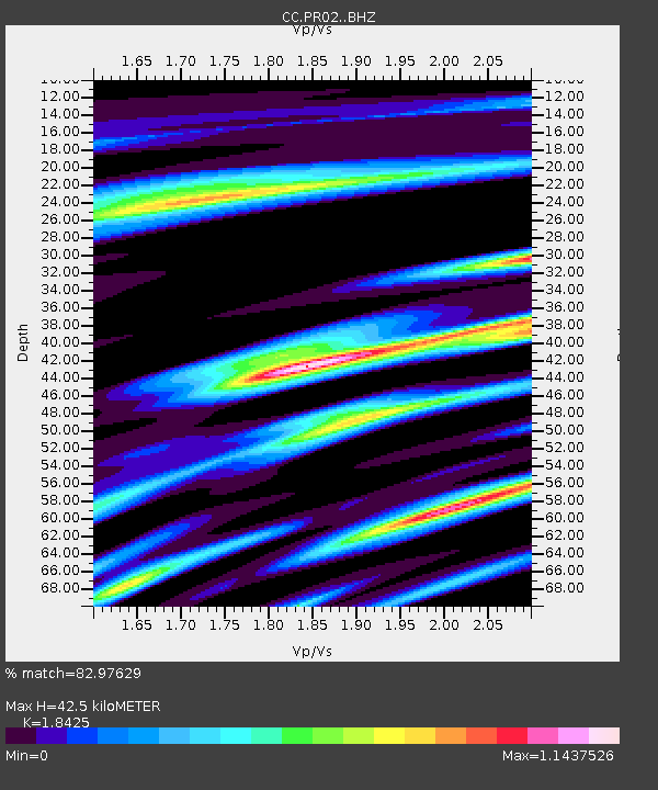
| Estimated Moho Depth: |
42.5 km |
| Estimated Crust Vp/Vs: |
1.84 |
| Assumed Crust Vp: |
6.566 km/s |
| Estimated Crust Vs: |
3.564 km/s |
| Estimated Crust Poisson's Ratio: |
0.29 |
|
| Radial Match: |
82.97629 % |
| Radial Bump: |
400 |
| Transverse Match: |
78.09438 % |
| Transverse Bump: |
400 |
| SOD ConfigId: |
13570011 |
| Insert Time: |
2019-04-29 13:35:22.203 +0000 |
| GWidth: |
2.5 |
| Max Bumps: |
400 |
| Tol: |
0.001 |
|

Signal To Noise
| Channel | StoN | STA | LTA |
| CC:PR02: :BHZ:20180114T09:29:54.679985Z | 21.546108 | 5.468997E-6 | 2.538276E-7 |
| CC:PR02: :BHN:20180114T09:29:54.679985Z | 4.0923815 | 1.5933025E-6 | 3.8933385E-7 |
| CC:PR02: :BHE:20180114T09:29:54.679985Z | 1.9109551 | 8.9485417E-7 | 4.6827589E-7 |
| Arrivals |
| Ps | 5.6 SECOND |
| PpPs | 18 SECOND |
| PsPs/PpSs | 23 SECOND |


