You are here: Home > Network List > TA - USArray Transportable Network (new EarthScope stations) Stations List
> Station V22A San Miguel Ranch, Cuba, NM, USA > Earthquake Result Viewer
V22A San Miguel Ranch, Cuba, NM, USA - Earthquake Result Viewer
| Earthquake location: |
Vanuatu Islands |
| Earthquake latitude/longitude: |
-14.8/168.0 |
| Earthquake time(UTC): |
2008/11/07 (312) 07:19:35 GMT |
| Earthquake Depth: |
13 km |
| Earthquake Magnitude: |
6.0 MB, 6.3 MS, 6.4 MW, 6.4 MW |
| Earthquake Catalog/Contributor: |
WHDF/NEIC |
|
| Network: |
TA USArray Transportable Network (new EarthScope stations) |
| Station: |
V22A San Miguel Ranch, Cuba, NM, USA |
| Lat/Lon: |
35.91 N/106.91 W |
| Elevation: |
2164 m |
|
| Distance: |
94.6 deg |
| Az: |
54.234 deg |
| Baz: |
255.17 deg |
| Ray Param: |
0.040992387 |
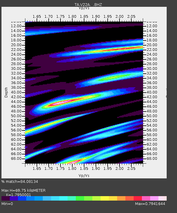
| Estimated Moho Depth: |
69.75 km |
| Estimated Crust Vp/Vs: |
1.80 |
| Assumed Crust Vp: |
6.502 km/s |
| Estimated Crust Vs: |
3.622 km/s |
| Estimated Crust Poisson's Ratio: |
0.27 |
|
| Radial Match: |
84.08134 % |
| Radial Bump: |
380 |
| Transverse Match: |
62.172176 % |
| Transverse Bump: |
398 |
| SOD ConfigId: |
2658 |
| Insert Time: |
2010-03-06 07:54:04.482 +0000 |
| GWidth: |
2.5 |
| Max Bumps: |
400 |
| Tol: |
0.001 |
|

Signal To Noise
| Channel | StoN | STA | LTA |
| TA:V22A: :BHZ:20081107T07:32:24.574014Z | 3.3263605 | 2.109903E-7 | 6.342978E-8 |
| TA:V22A: :BHN:20081107T07:32:24.574014Z | 1.9665316 | 2.9772025E-7 | 1.5139358E-7 |
| TA:V22A: :BHE:20081107T07:32:24.574014Z | 1.659928 | 1.6956619E-7 | 1.0215275E-7 |
| Arrivals |
| Ps | 8.7 SECOND |
| PpPs | 29 SECOND |
| PsPs/PpSs | 38 SECOND |


