You are here: Home > Network List > CH - Switzerland Seismological Network Stations List
> Station SENIN Lac Selin/Sanetsch > Earthquake Result Viewer
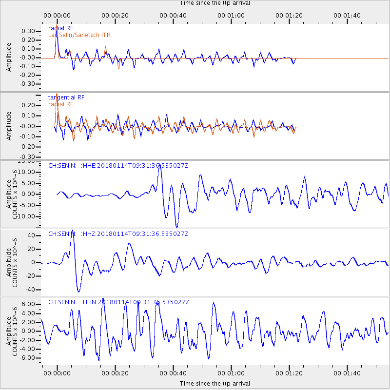
SENIN Lac Selin/Sanetsch - Earthquake Result Viewer

| Earthquake location: |
Near Coast Of Peru |
| Earthquake latitude/longitude: |
-15.8/-74.7 |
| Earthquake time(UTC): |
2018/01/14 (014) 09:18:45 GMT |
| Earthquake Depth: |
36 km |
| Earthquake Magnitude: |
7.1 mww |
| Earthquake Catalog/Contributor: |
NEIC PDE/us |
|
| Network: |
CH Switzerland Seismological Network |
| Station: |
SENIN Lac Selin/Sanetsch |
| Lat/Lon: |
46.36 N/7.30 E |
| Elevation: |
2035 m |
|
| Distance: |
95.9 deg |
| Az: |
43.589 deg |
| Baz: |
253.456 deg |
| Ray Param: |
0.04064548 |
| Estimated Moho Depth: |
41.25 km |
| Estimated Crust Vp/Vs: |
1.64 |
| Assumed Crust Vp: |
6.276 km/s |
| Estimated Crust Vs: |
3.815 km/s |
| Estimated Crust Poisson's Ratio: |
0.21 |
|
| Radial Match: |
85.93312 % |
| Radial Bump: |
400 |
| Transverse Match: |
75.783714 % |
| Transverse Bump: |
400 |
| SOD ConfigId: |
13570011 |
| Insert Time: |
2019-04-29 13:35:35.387 +0000 |
| GWidth: |
2.5 |
| Max Bumps: |
400 |
| Tol: |
0.001 |
|
Signal To Noise
| Channel | StoN | STA | LTA |
| CH:SENIN: :HHZ:20180114T09:31:36.535027Z | 8.180834 | 1.1500311E-5 | 1.4057628E-6 |
| CH:SENIN: :HHN:20180114T09:31:36.535027Z | 0.95236367 | 1.3375967E-6 | 1.4045021E-6 |
| CH:SENIN: :HHE:20180114T09:31:36.535027Z | 3.7399642 | 2.8010754E-6 | 7.489578E-7 |
| Arrivals |
| Ps | 4.3 SECOND |
| PpPs | 17 SECOND |
| PsPs/PpSs | 21 SECOND |


