You are here: Home > Network List > CI - Caltech Regional Seismic Network Stations List
> Station CIA CIA, Avalon Catalina Island, CA, USA > Earthquake Result Viewer
CIA CIA, Avalon Catalina Island, CA, USA - Earthquake Result Viewer
| Earthquake location: |
Near Coast Of Peru |
| Earthquake latitude/longitude: |
-15.8/-74.7 |
| Earthquake time(UTC): |
2018/01/14 (014) 09:18:45 GMT |
| Earthquake Depth: |
36 km |
| Earthquake Magnitude: |
7.1 mww |
| Earthquake Catalog/Contributor: |
NEIC PDE/us |
|
| Network: |
CI Caltech Regional Seismic Network |
| Station: |
CIA CIA, Avalon Catalina Island, CA, USA |
| Lat/Lon: |
33.40 N/118.41 W |
| Elevation: |
467 m |
|
| Distance: |
64.2 deg |
| Az: |
320.109 deg |
| Baz: |
132.426 deg |
| Ray Param: |
0.05898481 |
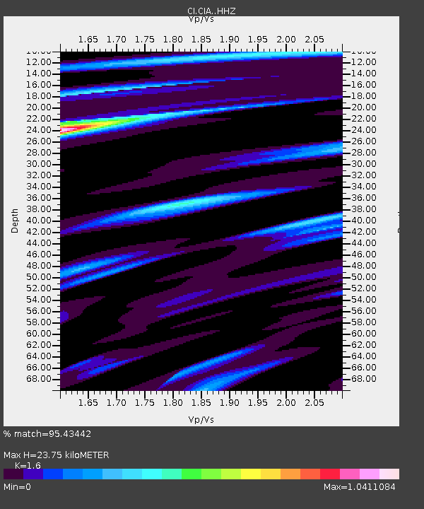
| Estimated Moho Depth: |
23.75 km |
| Estimated Crust Vp/Vs: |
1.60 |
| Assumed Crust Vp: |
6.048 km/s |
| Estimated Crust Vs: |
3.78 km/s |
| Estimated Crust Poisson's Ratio: |
0.18 |
|
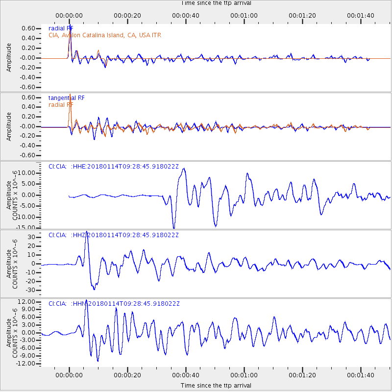
| Radial Match: |
95.43442 % |
| Radial Bump: |
393 |
| Transverse Match: |
89.38412 % |
| Transverse Bump: |
400 |
| SOD ConfigId: |
13570011 |
| Insert Time: |
2019-04-29 13:35:45.210 +0000 |
| GWidth: |
2.5 |
| Max Bumps: |
400 |
| Tol: |
0.001 |
|
Signal To Noise
| Channel | StoN | STA | LTA |
| CI:CIA: :HHZ:20180114T09:28:45.918022Z | 11.913045 | 4.1224907E-6 | 3.4604847E-7 |
| CI:CIA: :HHN:20180114T09:28:45.918022Z | 3.844719 | 1.4154824E-6 | 3.6816277E-7 |
| CI:CIA: :HHE:20180114T09:28:45.918022Z | 4.1276107 | 1.6112774E-6 | 3.9036564E-7 |
| Arrivals |
| Ps | 2.5 SECOND |
| PpPs | 9.8 SECOND |
| PsPs/PpSs | 12 SECOND |


