You are here: Home > Network List > TA - USArray Transportable Network (new EarthScope stations) Stations List
> Station V22A San Miguel Ranch, Cuba, NM, USA > Earthquake Result Viewer
V22A San Miguel Ranch, Cuba, NM, USA - Earthquake Result Viewer
| Earthquake location: |
Kermadec Islands Region |
| Earthquake latitude/longitude: |
-27.4/-176.3 |
| Earthquake time(UTC): |
2009/02/18 (049) 21:53:45 GMT |
| Earthquake Depth: |
25 km |
| Earthquake Magnitude: |
6.8 MB, 7.2 MS, 6.9 MW, 6.9 MW |
| Earthquake Catalog/Contributor: |
WHDF/NEIC |
|
| Network: |
TA USArray Transportable Network (new EarthScope stations) |
| Station: |
V22A San Miguel Ranch, Cuba, NM, USA |
| Lat/Lon: |
35.91 N/106.91 W |
| Elevation: |
2164 m |
|
| Distance: |
90.8 deg |
| Az: |
49.468 deg |
| Baz: |
236.329 deg |
| Ray Param: |
0.04164525 |
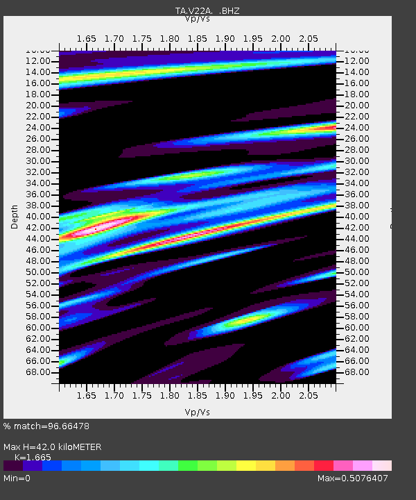
| Estimated Moho Depth: |
42.0 km |
| Estimated Crust Vp/Vs: |
1.66 |
| Assumed Crust Vp: |
6.502 km/s |
| Estimated Crust Vs: |
3.905 km/s |
| Estimated Crust Poisson's Ratio: |
0.22 |
|
| Radial Match: |
96.66478 % |
| Radial Bump: |
274 |
| Transverse Match: |
89.14692 % |
| Transverse Bump: |
400 |
| SOD ConfigId: |
2658 |
| Insert Time: |
2010-03-06 07:54:12.682 +0000 |
| GWidth: |
2.5 |
| Max Bumps: |
400 |
| Tol: |
0.001 |
|

Signal To Noise
| Channel | StoN | STA | LTA |
| TA:V22A: :BHZ:20090218T22:06:14.649014Z | 12.59605 | 2.3666682E-6 | 1.8788971E-7 |
| TA:V22A: :BHN:20090218T22:06:14.649014Z | 1.5016462 | 3.5713052E-7 | 2.3782603E-7 |
| TA:V22A: :BHE:20090218T22:06:14.649014Z | 2.9153996 | 8.0793853E-7 | 2.771279E-7 |
| Arrivals |
| Ps | 4.4 SECOND |
| PpPs | 17 SECOND |
| PsPs/PpSs | 21 SECOND |


