You are here: Home > Network List > CI - Caltech Regional Seismic Network Stations List
> Station GSC Goldstone, Goldstone Lake, CA, USA > Earthquake Result Viewer
GSC Goldstone, Goldstone Lake, CA, USA - Earthquake Result Viewer
| Earthquake location: |
Near Coast Of Peru |
| Earthquake latitude/longitude: |
-15.8/-74.7 |
| Earthquake time(UTC): |
2018/01/14 (014) 09:18:45 GMT |
| Earthquake Depth: |
36 km |
| Earthquake Magnitude: |
7.1 mww |
| Earthquake Catalog/Contributor: |
NEIC PDE/us |
|
| Network: |
CI Caltech Regional Seismic Network |
| Station: |
GSC Goldstone, Goldstone Lake, CA, USA |
| Lat/Lon: |
35.30 N/116.81 W |
| Elevation: |
1000 m |
|
| Distance: |
64.6 deg |
| Az: |
322.649 deg |
| Baz: |
134.426 deg |
| Ray Param: |
0.058769647 |
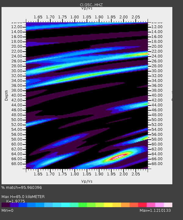
| Estimated Moho Depth: |
65.0 km |
| Estimated Crust Vp/Vs: |
1.98 |
| Assumed Crust Vp: |
6.276 km/s |
| Estimated Crust Vs: |
3.174 km/s |
| Estimated Crust Poisson's Ratio: |
0.33 |
|
| Radial Match: |
95.960396 % |
| Radial Bump: |
341 |
| Transverse Match: |
85.71246 % |
| Transverse Bump: |
400 |
| SOD ConfigId: |
13570011 |
| Insert Time: |
2019-04-29 13:35:54.022 +0000 |
| GWidth: |
2.5 |
| Max Bumps: |
400 |
| Tol: |
0.001 |
|
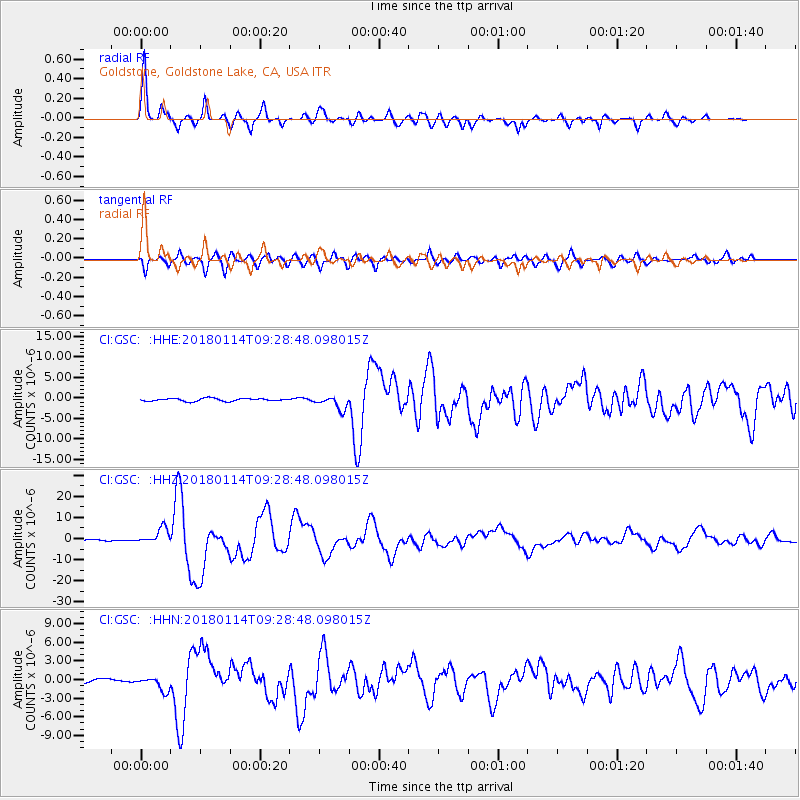
Signal To Noise
| Channel | StoN | STA | LTA |
| CI:GSC: :HHZ:20180114T09:28:48.098015Z | 11.179899 | 3.7623108E-6 | 3.3652458E-7 |
| CI:GSC: :HHN:20180114T09:28:48.098015Z | 3.125979 | 1.1928297E-6 | 3.8158598E-7 |
| CI:GSC: :HHE:20180114T09:28:48.098015Z | 4.7341895 | 1.6405496E-6 | 3.4653232E-7 |
| Arrivals |
| Ps | 10 SECOND |
| PpPs | 30 SECOND |
| PsPs/PpSs | 40 SECOND |


