You are here: Home > Network List > TA - USArray Transportable Network (new EarthScope stations) Stations List
> Station V22A San Miguel Ranch, Cuba, NM, USA > Earthquake Result Viewer
V22A San Miguel Ranch, Cuba, NM, USA - Earthquake Result Viewer
| Earthquake location: |
Off Coast Of Costa Rica |
| Earthquake latitude/longitude: |
7.9/-85.6 |
| Earthquake time(UTC): |
2009/08/13 (225) 09:37:35 GMT |
| Earthquake Depth: |
10 km |
| Earthquake Magnitude: |
5.8 MW, 5.3 MB |
| Earthquake Catalog/Contributor: |
WHDF/NEIC |
|
| Network: |
TA USArray Transportable Network (new EarthScope stations) |
| Station: |
V22A San Miguel Ranch, Cuba, NM, USA |
| Lat/Lon: |
35.91 N/106.91 W |
| Elevation: |
2164 m |
|
| Distance: |
34.0 deg |
| Az: |
328.171 deg |
| Baz: |
139.945 deg |
| Ray Param: |
0.077969916 |
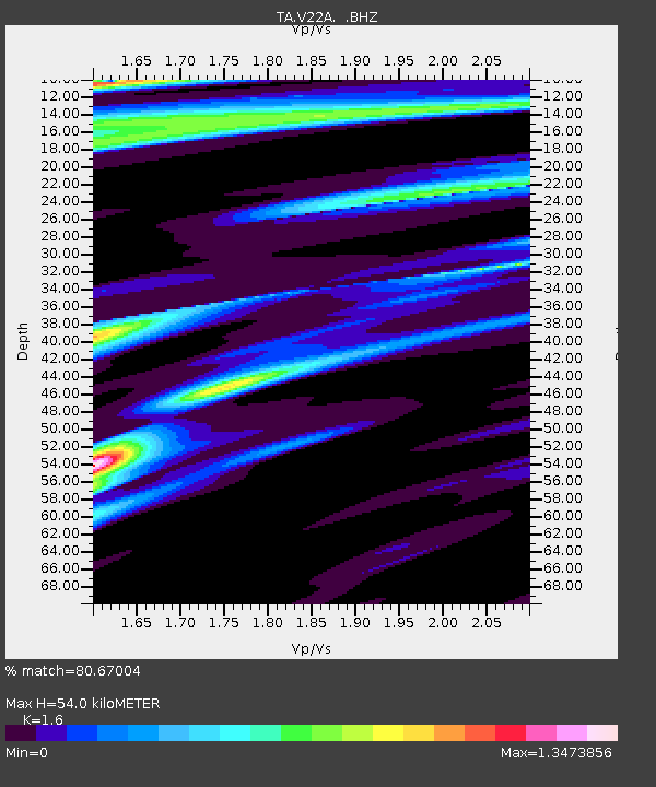
| Estimated Moho Depth: |
54.0 km |
| Estimated Crust Vp/Vs: |
1.60 |
| Assumed Crust Vp: |
6.502 km/s |
| Estimated Crust Vs: |
4.063 km/s |
| Estimated Crust Poisson's Ratio: |
0.18 |
|
| Radial Match: |
80.67004 % |
| Radial Bump: |
299 |
| Transverse Match: |
63.87914 % |
| Transverse Bump: |
331 |
| SOD ConfigId: |
2622 |
| Insert Time: |
2010-03-06 07:54:18.526 +0000 |
| GWidth: |
2.5 |
| Max Bumps: |
400 |
| Tol: |
0.001 |
|

Signal To Noise
| Channel | StoN | STA | LTA |
| TA:V22A: :BHZ:20090813T09:43:48.024011Z | 2.7151587 | 2.6459082E-7 | 9.744949E-8 |
| TA:V22A: :BHN:20090813T09:43:48.024011Z | 1.4546558 | 1.0129772E-7 | 6.96369E-8 |
| TA:V22A: :BHE:20090813T09:43:48.024011Z | 1.4399966 | 8.667474E-8 | 6.0190935E-8 |
| Arrivals |
| Ps | 5.4 SECOND |
| PpPs | 20 SECOND |
| PsPs/PpSs | 25 SECOND |


