You are here: Home > Network List > GS - US Geological Survey Networks Stations List
> Station OK039 N2440 and E0440 Rds, Cleo Springs, OK, USA > Earthquake Result Viewer
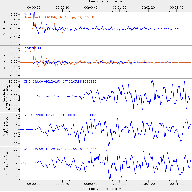
OK039 N2440 and E0440 Rds, Cleo Springs, OK, USA - Earthquake Result Viewer

| Earthquake location: |
Near Coast Of Ecuador |
| Earthquake latitude/longitude: |
0.4/-79.9 |
| Earthquake time(UTC): |
2016/04/16 (107) 23:58:37 GMT |
| Earthquake Depth: |
19 km |
| Earthquake Magnitude: |
7.8 MWW, 7.4 MI |
| Earthquake Catalog/Contributor: |
NEIC PDE/NEIC COMCAT |
|
| Network: |
GS US Geological Survey Networks |
| Station: |
OK039 N2440 and E0440 Rds, Cleo Springs, OK, USA |
| Lat/Lon: |
36.38 N/98.65 W |
| Elevation: |
400 m |
|
| Distance: |
39.8 deg |
| Az: |
336.152 deg |
| Baz: |
149.933 deg |
| Ray Param: |
0.074739486 |
| Estimated Moho Depth: |
50.5 km |
| Estimated Crust Vp/Vs: |
1.64 |
| Assumed Crust Vp: |
6.426 km/s |
| Estimated Crust Vs: |
3.912 km/s |
| Estimated Crust Poisson's Ratio: |
0.21 |
|
| Radial Match: |
96.50579 % |
| Radial Bump: |
325 |
| Transverse Match: |
88.40409 % |
| Transverse Bump: |
400 |
| SOD ConfigId: |
1475611 |
| Insert Time: |
2016-05-01 00:05:29.883 +0000 |
| GWidth: |
2.5 |
| Max Bumps: |
400 |
| Tol: |
0.001 |
|
Signal To Noise
| Channel | StoN | STA | LTA |
| GS:OK039:00:HHZ:20160417T00:05:38.398988Z | 15.185156 | 3.5428614E-6 | 2.3331083E-7 |
| GS:OK039:00:HH1:20160417T00:05:38.398988Z | 7.3795023 | 1.8217456E-6 | 2.4686565E-7 |
| GS:OK039:00:HH2:20160417T00:05:38.398988Z | 7.4479976 | 1.7382147E-6 | 2.3338013E-7 |
| Arrivals |
| Ps | 5.5 SECOND |
| PpPs | 19 SECOND |
| PsPs/PpSs | 25 SECOND |


