You are here: Home > Network List > TA - USArray Transportable Network (new EarthScope stations) Stations List
> Station V22A San Miguel Ranch, Cuba, NM, USA > Earthquake Result Viewer
V22A San Miguel Ranch, Cuba, NM, USA - Earthquake Result Viewer
| Earthquake location: |
Near Coast Of Venezuela |
| Earthquake latitude/longitude: |
10.7/-67.9 |
| Earthquake time(UTC): |
2009/09/12 (255) 20:06:24 GMT |
| Earthquake Depth: |
10 km |
| Earthquake Magnitude: |
6.3 MB, 6.4 MS, 6.3 MW, 6.3 MW |
| Earthquake Catalog/Contributor: |
WHDF/NEIC |
|
| Network: |
TA USArray Transportable Network (new EarthScope stations) |
| Station: |
V22A San Miguel Ranch, Cuba, NM, USA |
| Lat/Lon: |
35.91 N/106.91 W |
| Elevation: |
2164 m |
|
| Distance: |
43.3 deg |
| Az: |
311.853 deg |
| Baz: |
115.602 deg |
| Ray Param: |
0.0726476 |
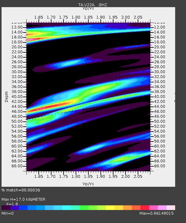
| Estimated Moho Depth: |
17.0 km |
| Estimated Crust Vp/Vs: |
1.60 |
| Assumed Crust Vp: |
6.502 km/s |
| Estimated Crust Vs: |
4.063 km/s |
| Estimated Crust Poisson's Ratio: |
0.18 |
|
| Radial Match: |
88.88836 % |
| Radial Bump: |
400 |
| Transverse Match: |
82.9391 % |
| Transverse Bump: |
400 |
| SOD ConfigId: |
2622 |
| Insert Time: |
2010-03-06 07:54:26.643 +0000 |
| GWidth: |
2.5 |
| Max Bumps: |
400 |
| Tol: |
0.001 |
|

Signal To Noise
| Channel | StoN | STA | LTA |
| TA:V22A: :BHZ:20090912T20:13:55.550005Z | 6.108553 | 8.935511E-7 | 1.462787E-7 |
| TA:V22A: :BHN:20090912T20:13:55.550005Z | 1.2324992 | 1.9383464E-7 | 1.5726958E-7 |
| TA:V22A: :BHE:20090912T20:13:55.550005Z | 1.9040328 | 3.3725084E-7 | 1.7712449E-7 |
| Arrivals |
| Ps | 1.7 SECOND |
| PpPs | 6.3 SECOND |
| PsPs/PpSs | 8.0 SECOND |


