You are here: Home > Network List > CN - Canadian National Seismograph Network Stations List
> Station NBC4 Z > Earthquake Result Viewer
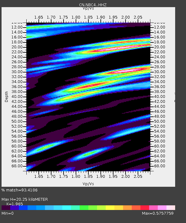
NBC4 Z - Earthquake Result Viewer
| Earthquake location: |
Near Coast Of Peru |
| Earthquake latitude/longitude: |
-15.8/-74.7 |
| Earthquake time(UTC): |
2018/01/14 (014) 09:18:45 GMT |
| Earthquake Depth: |
36 km |
| Earthquake Magnitude: |
7.1 mww |
| Earthquake Catalog/Contributor: |
NEIC PDE/us |
|
| Network: |
CN Canadian National Seismograph Network |
| Station: |
NBC4 Z |
| Lat/Lon: |
55.69 N/120.66 W |
| Elevation: |
0.0 m |
|
| Distance: |
81.0 deg |
| Az: |
335.677 deg |
| Baz: |
135.552 deg |
| Ray Param: |
0.04784915 |
| Estimated Moho Depth: |
20.25 km |
| Estimated Crust Vp/Vs: |
1.97 |
| Assumed Crust Vp: |
6.303 km/s |
| Estimated Crust Vs: |
3.207 km/s |
| Estimated Crust Poisson's Ratio: |
0.33 |
|
| Radial Match: |
93.4186 % |
| Radial Bump: |
400 |
| Transverse Match: |
74.83663 % |
| Transverse Bump: |
400 |
| SOD ConfigId: |
13570011 |
| Insert Time: |
2019-04-29 13:36:54.101 +0000 |
| GWidth: |
2.5 |
| Max Bumps: |
400 |
| Tol: |
0.001 |
|

Signal To Noise
| Channel | StoN | STA | LTA |
| CN:NBC4: :HHZ:20180114T09:30:25.039971Z | 15.1799 | 1.3289332E-5 | 8.754558E-7 |
| CN:NBC4: :HHN:20180114T09:30:25.039971Z | 3.6701944 | 2.7016144E-6 | 7.360957E-7 |
| CN:NBC4: :HHE:20180114T09:30:25.039971Z | 3.963417 | 3.17082E-6 | 8.000218E-7 |
| Arrivals |
| Ps | 3.2 SECOND |
| PpPs | 9.3 SECOND |
| PsPs/PpSs | 12 SECOND |


