You are here: Home > Network List > CN - Canadian National Seismograph Network Stations List
> Station VIMO VICTOR MINE, ON > Earthquake Result Viewer
VIMO VICTOR MINE, ON - Earthquake Result Viewer
| Earthquake location: |
Near Coast Of Peru |
| Earthquake latitude/longitude: |
-15.8/-74.7 |
| Earthquake time(UTC): |
2018/01/14 (014) 09:18:45 GMT |
| Earthquake Depth: |
36 km |
| Earthquake Magnitude: |
7.1 mww |
| Earthquake Catalog/Contributor: |
NEIC PDE/us |
|
| Network: |
CN Canadian National Seismograph Network |
| Station: |
VIMO VICTOR MINE, ON |
| Lat/Lon: |
52.82 N/83.74 W |
| Elevation: |
78 m |
|
| Distance: |
68.8 deg |
| Az: |
354.153 deg |
| Baz: |
170.699 deg |
| Ray Param: |
0.056040615 |
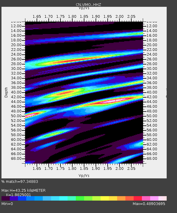
| Estimated Moho Depth: |
43.25 km |
| Estimated Crust Vp/Vs: |
1.98 |
| Assumed Crust Vp: |
6.459 km/s |
| Estimated Crust Vs: |
3.258 km/s |
| Estimated Crust Poisson's Ratio: |
0.33 |
|
| Radial Match: |
97.34883 % |
| Radial Bump: |
283 |
| Transverse Match: |
80.8222 % |
| Transverse Bump: |
400 |
| SOD ConfigId: |
13570011 |
| Insert Time: |
2019-04-29 13:37:10.492 +0000 |
| GWidth: |
2.5 |
| Max Bumps: |
400 |
| Tol: |
0.001 |
|

Signal To Noise
| Channel | StoN | STA | LTA |
| CN:VIMO: :HHZ:20180114T09:29:14.479973Z | 26.756454 | 1.30823755E-5 | 4.889428E-7 |
| CN:VIMO: :HHN:20180114T09:29:14.479973Z | 13.075615 | 6.0276893E-6 | 4.6098705E-7 |
| CN:VIMO: :HHE:20180114T09:29:14.479973Z | 3.116231 | 1.2162985E-6 | 3.903108E-7 |
| Arrivals |
| Ps | 6.8 SECOND |
| PpPs | 19 SECOND |
| PsPs/PpSs | 26 SECOND |


