You are here: Home > Network List > TA - USArray Transportable Network (new EarthScope stations) Stations List
> Station V22A San Miguel Ranch, Cuba, NM, USA > Earthquake Result Viewer
V22A San Miguel Ranch, Cuba, NM, USA - Earthquake Result Viewer

| Earthquake location: |
Kodiak Island Region, Alaska |
| Earthquake latitude/longitude: |
56.5/-152.7 |
| Earthquake time(UTC): |
2009/03/30 (089) 07:13:07 GMT |
| Earthquake Depth: |
21 km |
| Earthquake Magnitude: |
5.9 MB, 5.9 MS, 5.9 MW, 5.9 MW |
| Earthquake Catalog/Contributor: |
WHDF/NEIC |
|
| Network: |
TA USArray Transportable Network (new EarthScope stations) |
| Station: |
V22A San Miguel Ranch, Cuba, NM, USA |
| Lat/Lon: |
35.91 N/106.91 W |
| Elevation: |
2164 m |
|
| Distance: |
36.9 deg |
| Az: |
104.213 deg |
| Baz: |
318.594 deg |
| Ray Param: |
0.07639152 |
| Estimated Moho Depth: |
40.5 km |
| Estimated Crust Vp/Vs: |
1.88 |
| Assumed Crust Vp: |
6.502 km/s |
| Estimated Crust Vs: |
3.458 km/s |
| Estimated Crust Poisson's Ratio: |
0.30 |
|
| Radial Match: |
80.70822 % |
| Radial Bump: |
312 |
| Transverse Match: |
68.43441 % |
| Transverse Bump: |
331 |
| SOD ConfigId: |
2658 |
| Insert Time: |
2010-03-06 07:54:43.606 +0000 |
| GWidth: |
2.5 |
| Max Bumps: |
400 |
| Tol: |
0.001 |
|
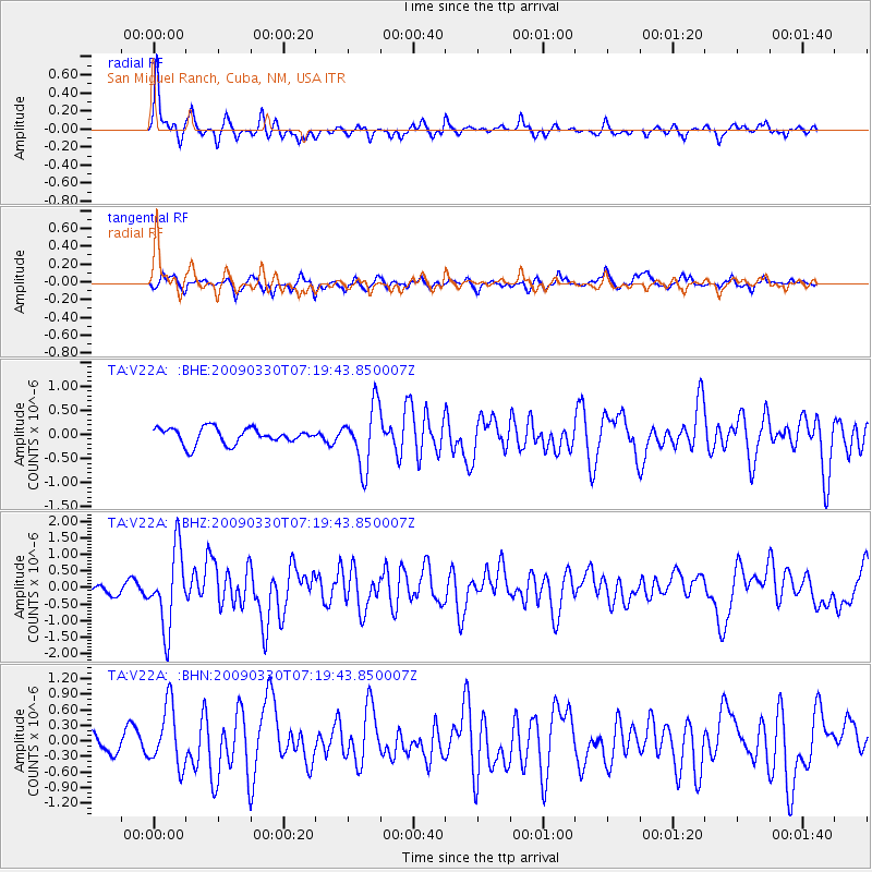
Signal To Noise
| Channel | StoN | STA | LTA |
| TA:V22A: :BHZ:20090330T07:19:43.850007Z | 8.260408 | 1.1577009E-6 | 1.4015056E-7 |
| TA:V22A: :BHN:20090330T07:19:43.850007Z | 3.4248734 | 5.821079E-7 | 1.6996479E-7 |
| TA:V22A: :BHE:20090330T07:19:43.850007Z | 3.8186922 | 6.2589726E-7 | 1.6390355E-7 |
| Arrivals |
| Ps | 5.9 SECOND |
| PpPs | 17 SECOND |
| PsPs/PpSs | 23 SECOND |


