You are here: Home > Network List > II - Global Seismograph Network (GSN - IRIS/IDA) Stations List
> Station CMLA Cha de Macela, Sao Miguel Island, Azores > Earthquake Result Viewer
CMLA Cha de Macela, Sao Miguel Island, Azores - Earthquake Result Viewer

| Earthquake location: |
Near Coast Of Ecuador |
| Earthquake latitude/longitude: |
0.4/-79.9 |
| Earthquake time(UTC): |
2016/04/16 (107) 23:58:37 GMT |
| Earthquake Depth: |
19 km |
| Earthquake Magnitude: |
7.8 MWW, 7.4 MI |
| Earthquake Catalog/Contributor: |
NEIC PDE/NEIC COMCAT |
|
| Network: |
II Global Seismograph Network (GSN - IRIS/IDA) |
| Station: |
CMLA Cha de Macela, Sao Miguel Island, Azores |
| Lat/Lon: |
37.76 N/25.52 W |
| Elevation: |
429 m |
|
| Distance: |
62.3 deg |
| Az: |
46.725 deg |
| Baz: |
246.729 deg |
| Ray Param: |
0.06030778 |
| Estimated Moho Depth: |
65.5 km |
| Estimated Crust Vp/Vs: |
1.91 |
| Assumed Crust Vp: |
4.802 km/s |
| Estimated Crust Vs: |
2.514 km/s |
| Estimated Crust Poisson's Ratio: |
0.31 |
|
| Radial Match: |
93.767105 % |
| Radial Bump: |
362 |
| Transverse Match: |
84.452324 % |
| Transverse Bump: |
400 |
| SOD ConfigId: |
1475611 |
| Insert Time: |
2016-05-01 00:06:41.220 +0000 |
| GWidth: |
2.5 |
| Max Bumps: |
400 |
| Tol: |
0.001 |
|
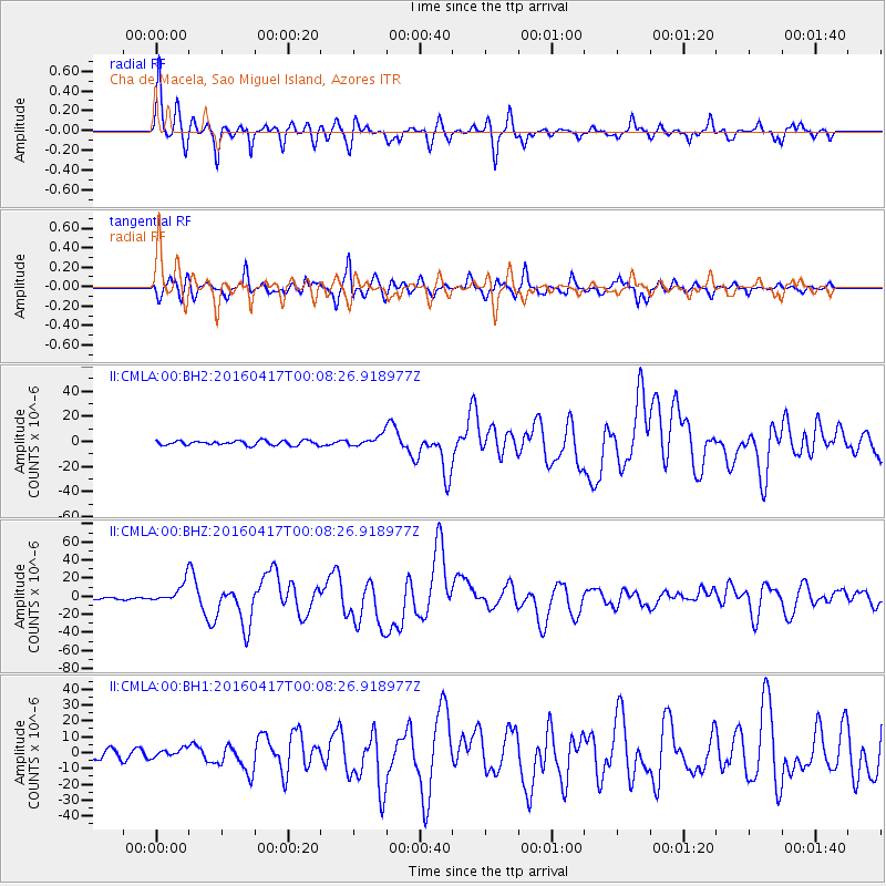
Signal To Noise
| Channel | StoN | STA | LTA |
| II:CMLA:00:BHZ:20160417T00:08:26.918977Z | 10.100677 | 1.1381354E-5 | 1.1267913E-6 |
| II:CMLA:00:BH1:20160417T00:08:26.918977Z | 1.4046872 | 2.5834938E-6 | 1.8391952E-6 |
| II:CMLA:00:BH2:20160417T00:08:26.918977Z | 2.3971355 | 4.319106E-6 | 1.8017782E-6 |
| Arrivals |
| Ps | 13 SECOND |
| PpPs | 39 SECOND |
| PsPs/PpSs | 52 SECOND |


