You are here: Home > Network List > TA - USArray Transportable Network (new EarthScope stations) Stations List
> Station V22A San Miguel Ranch, Cuba, NM, USA > Earthquake Result Viewer
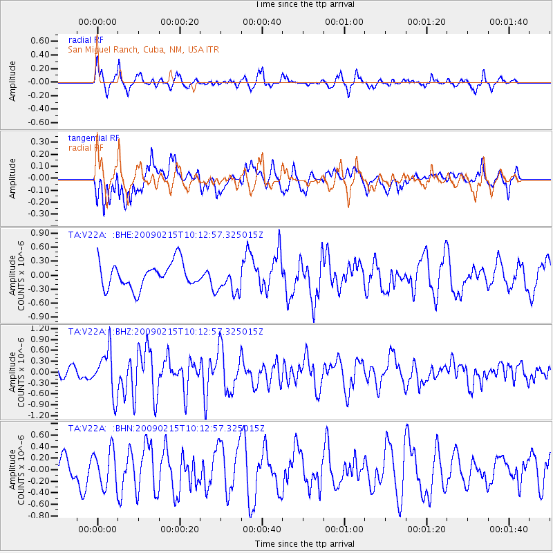
V22A San Miguel Ranch, Cuba, NM, USA - Earthquake Result Viewer
*The percent match for this event was below the threshold and hence no stack was calculated.
| Earthquake location: |
Near Coast Of Northern Peru |
| Earthquake latitude/longitude: |
-5.9/-80.9 |
| Earthquake time(UTC): |
2009/02/15 (046) 10:04:49 GMT |
| Earthquake Depth: |
21 km |
| Earthquake Magnitude: |
5.8 MB, 5.7 MS, 6.1 MW, 6.1 MW |
| Earthquake Catalog/Contributor: |
WHDF/NEIC |
|
| Network: |
TA USArray Transportable Network (new EarthScope stations) |
| Station: |
V22A San Miguel Ranch, Cuba, NM, USA |
| Lat/Lon: |
35.91 N/106.91 W |
| Elevation: |
2164 m |
|
| Distance: |
48.2 deg |
| Az: |
331.465 deg |
| Baz: |
144.167 deg |
| Ray Param: |
$rayparam |
*The percent match for this event was below the threshold and hence was not used in the summary stack. |
|
| Radial Match: |
71.000206 % |
| Radial Bump: |
356 |
| Transverse Match: |
51.201656 % |
| Transverse Bump: |
400 |
| SOD ConfigId: |
2658 |
| Insert Time: |
2010-03-06 07:55:05.304 +0000 |
| GWidth: |
2.5 |
| Max Bumps: |
400 |
| Tol: |
0.001 |
|
Signal To Noise
| Channel | StoN | STA | LTA |
| TA:V22A: :BHZ:20090215T10:12:57.325015Z | 2.9231308 | 6.316882E-7 | 2.1609986E-7 |
| TA:V22A: :BHN:20090215T10:12:57.325015Z | 1.2956942 | 3.2371773E-7 | 2.4984115E-7 |
| TA:V22A: :BHE:20090215T10:12:57.325015Z | 1.0914114 | 2.9156212E-7 | 2.671423E-7 |
| Arrivals |
| Ps | |
| PpPs | |
| PsPs/PpSs | |


