You are here: Home > Network List > LD - Lamont-Doherty Cooperative Seismographic Network Stations List
> Station TRNY Table Rock, Ramapo, NY > Earthquake Result Viewer
TRNY Table Rock, Ramapo, NY - Earthquake Result Viewer
| Earthquake location: |
Near Coast Of Peru |
| Earthquake latitude/longitude: |
-15.8/-74.7 |
| Earthquake time(UTC): |
2018/01/14 (014) 09:18:45 GMT |
| Earthquake Depth: |
36 km |
| Earthquake Magnitude: |
7.1 mww |
| Earthquake Catalog/Contributor: |
NEIC PDE/us |
|
| Network: |
LD Lamont-Doherty Cooperative Seismographic Network |
| Station: |
TRNY Table Rock, Ramapo, NY |
| Lat/Lon: |
41.15 N/74.22 W |
| Elevation: |
270 m |
|
| Distance: |
56.6 deg |
| Az: |
0.47 deg |
| Baz: |
180.599 deg |
| Ray Param: |
0.06394623 |
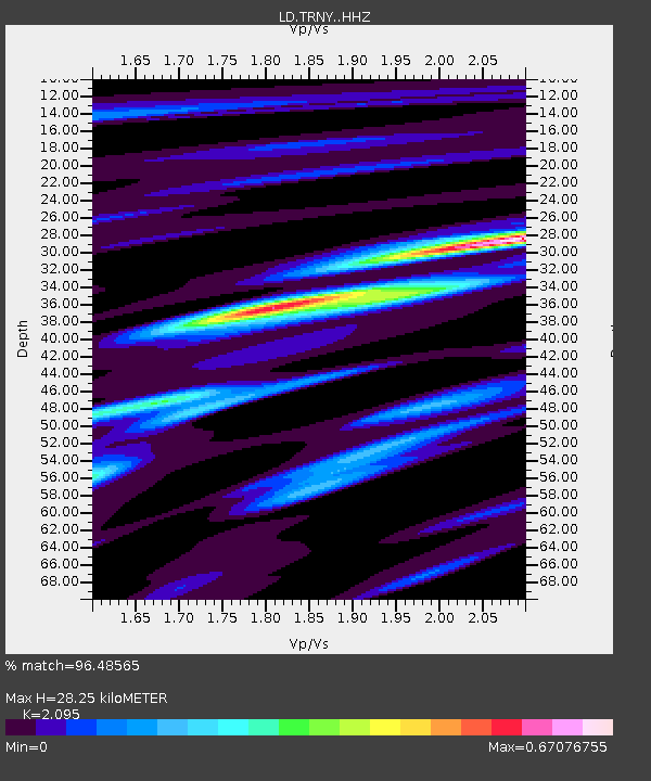
| Estimated Moho Depth: |
28.25 km |
| Estimated Crust Vp/Vs: |
2.10 |
| Assumed Crust Vp: |
6.283 km/s |
| Estimated Crust Vs: |
2.999 km/s |
| Estimated Crust Poisson's Ratio: |
0.35 |
|
| Radial Match: |
96.48565 % |
| Radial Bump: |
248 |
| Transverse Match: |
84.78522 % |
| Transverse Bump: |
400 |
| SOD ConfigId: |
13570011 |
| Insert Time: |
2019-04-29 13:38:37.874 +0000 |
| GWidth: |
2.5 |
| Max Bumps: |
400 |
| Tol: |
0.001 |
|

Signal To Noise
| Channel | StoN | STA | LTA |
| LD:TRNY: :HHZ:20180114T09:27:53.895012Z | 15.860826 | 1.1291605E-5 | 7.1191783E-7 |
| LD:TRNY: :HHN:20180114T09:27:53.895012Z | 11.069641 | 5.9407453E-6 | 5.366701E-7 |
| LD:TRNY: :HHE:20180114T09:27:53.895012Z | 0.8399837 | 5.368675E-7 | 6.391404E-7 |
| Arrivals |
| Ps | 5.1 SECOND |
| PpPs | 13 SECOND |
| PsPs/PpSs | 18 SECOND |


