You are here: Home > Network List > LD - Lamont-Doherty Cooperative Seismographic Network Stations List
> Station UNH University of New Hampshire, Durham, NH, USA > Earthquake Result Viewer
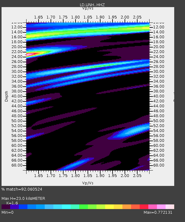
UNH University of New Hampshire, Durham, NH, USA - Earthquake Result Viewer
| Earthquake location: |
Near Coast Of Peru |
| Earthquake latitude/longitude: |
-15.8/-74.7 |
| Earthquake time(UTC): |
2018/01/14 (014) 09:18:45 GMT |
| Earthquake Depth: |
36 km |
| Earthquake Magnitude: |
7.1 mww |
| Earthquake Catalog/Contributor: |
NEIC PDE/us |
|
| Network: |
LD Lamont-Doherty Cooperative Seismographic Network |
| Station: |
UNH University of New Hampshire, Durham, NH, USA |
| Lat/Lon: |
43.09 N/70.87 W |
| Elevation: |
5.0 m |
|
| Distance: |
58.7 deg |
| Az: |
3.325 deg |
| Baz: |
184.373 deg |
| Ray Param: |
0.062616885 |
| Estimated Moho Depth: |
23.0 km |
| Estimated Crust Vp/Vs: |
1.60 |
| Assumed Crust Vp: |
6.419 km/s |
| Estimated Crust Vs: |
4.012 km/s |
| Estimated Crust Poisson's Ratio: |
0.18 |
|
| Radial Match: |
92.060524 % |
| Radial Bump: |
355 |
| Transverse Match: |
72.75111 % |
| Transverse Bump: |
400 |
| SOD ConfigId: |
13570011 |
| Insert Time: |
2019-04-29 13:38:39.914 +0000 |
| GWidth: |
2.5 |
| Max Bumps: |
400 |
| Tol: |
0.001 |
|

Signal To Noise
| Channel | StoN | STA | LTA |
| LD:UNH: :HHZ:20180114T09:28:08.275017Z | 5.5712876 | 9.421836E-6 | 1.6911416E-6 |
| LD:UNH: :HHN:20180114T09:28:08.275017Z | 6.2866406 | 5.042096E-6 | 8.0203347E-7 |
| LD:UNH: :HHE:20180114T09:28:08.275017Z | 0.6380596 | 7.2936837E-7 | 1.1431038E-6 |
| Arrivals |
| Ps | 2.3 SECOND |
| PpPs | 8.8 SECOND |
| PsPs/PpSs | 11 SECOND |


