You are here: Home > Network List > LX - University of LISbon SEISmic Network Stations List
> Station MORF Marmelete, Algarve, Portugal > Earthquake Result Viewer
MORF Marmelete, Algarve, Portugal - Earthquake Result Viewer
| Earthquake location: |
Near Coast Of Peru |
| Earthquake latitude/longitude: |
-15.8/-74.7 |
| Earthquake time(UTC): |
2018/01/14 (014) 09:18:45 GMT |
| Earthquake Depth: |
36 km |
| Earthquake Magnitude: |
7.1 mww |
| Earthquake Catalog/Contributor: |
NEIC PDE/us |
|
| Network: |
LX University of LISbon SEISmic Network |
| Station: |
MORF Marmelete, Algarve, Portugal |
| Lat/Lon: |
37.30 N/8.65 W |
| Elevation: |
560 m |
|
| Distance: |
81.5 deg |
| Az: |
47.484 deg |
| Baz: |
242.874 deg |
| Ray Param: |
0.047502045 |
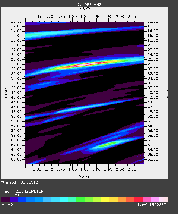
| Estimated Moho Depth: |
28.0 km |
| Estimated Crust Vp/Vs: |
1.85 |
| Assumed Crust Vp: |
6.048 km/s |
| Estimated Crust Vs: |
3.269 km/s |
| Estimated Crust Poisson's Ratio: |
0.29 |
|
| Radial Match: |
88.25512 % |
| Radial Bump: |
266 |
| Transverse Match: |
81.58388 % |
| Transverse Bump: |
347 |
| SOD ConfigId: |
13570011 |
| Insert Time: |
2019-04-29 13:38:43.661 +0000 |
| GWidth: |
2.5 |
| Max Bumps: |
400 |
| Tol: |
0.001 |
|

Signal To Noise
| Channel | StoN | STA | LTA |
| LX:MORF: :HHZ:20180114T09:30:27.475029Z | 7.872011 | 4.5399743E-6 | 5.7672355E-7 |
| LX:MORF: :HHN:20180114T09:30:27.475029Z | 2.3239849 | 7.777817E-7 | 3.346759E-7 |
| LX:MORF: :HHE:20180114T09:30:27.475029Z | 3.1661682 | 1.7631976E-6 | 5.568869E-7 |
| Arrivals |
| Ps | 4.0 SECOND |
| PpPs | 13 SECOND |
| PsPs/PpSs | 17 SECOND |


