You are here: Home > Network List > N4 - Central and EAstern US Network Stations List
> Station 146B Union, MS, USA > Earthquake Result Viewer
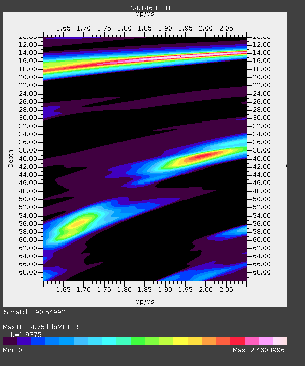
146B Union, MS, USA - Earthquake Result Viewer
| Earthquake location: |
Near Coast Of Peru |
| Earthquake latitude/longitude: |
-15.8/-74.7 |
| Earthquake time(UTC): |
2018/01/14 (014) 09:18:45 GMT |
| Earthquake Depth: |
36 km |
| Earthquake Magnitude: |
7.1 mww |
| Earthquake Catalog/Contributor: |
NEIC PDE/us |
|
| Network: |
N4 Central and EAstern US Network |
| Station: |
146B Union, MS, USA |
| Lat/Lon: |
32.64 N/89.06 W |
| Elevation: |
161 m |
|
| Distance: |
50.0 deg |
| Az: |
344.211 deg |
| Baz: |
161.911 deg |
| Ray Param: |
0.06823927 |
| Estimated Moho Depth: |
14.75 km |
| Estimated Crust Vp/Vs: |
1.94 |
| Assumed Crust Vp: |
6.201 km/s |
| Estimated Crust Vs: |
3.201 km/s |
| Estimated Crust Poisson's Ratio: |
0.32 |
|
| Radial Match: |
90.54992 % |
| Radial Bump: |
355 |
| Transverse Match: |
71.58572 % |
| Transverse Bump: |
400 |
| SOD ConfigId: |
13570011 |
| Insert Time: |
2019-04-29 13:38:54.572 +0000 |
| GWidth: |
2.5 |
| Max Bumps: |
400 |
| Tol: |
0.001 |
|

Signal To Noise
| Channel | StoN | STA | LTA |
| N4:146B: :HHZ:20180114T09:27:05.730004Z | 46.256718 | 2.1919075E-5 | 4.738571E-7 |
| N4:146B: :HHN:20180114T09:27:05.730004Z | 6.9847546 | 7.817776E-6 | 1.1192628E-6 |
| N4:146B: :HHE:20180114T09:27:05.730004Z | 2.0523791 | 3.1943493E-6 | 1.5564128E-6 |
| Arrivals |
| Ps | 2.3 SECOND |
| PpPs | 6.7 SECOND |
| PsPs/PpSs | 9.0 SECOND |


