You are here: Home > Network List > IU - Global Seismograph Network (GSN - IRIS/USGS) Stations List
> Station COR Corvallis, Oregon, USA > Earthquake Result Viewer
COR Corvallis, Oregon, USA - Earthquake Result Viewer
| Earthquake location: |
Near Coast Of Ecuador |
| Earthquake latitude/longitude: |
0.4/-79.9 |
| Earthquake time(UTC): |
2016/04/16 (107) 23:58:37 GMT |
| Earthquake Depth: |
19 km |
| Earthquake Magnitude: |
7.8 MWW, 7.4 MI |
| Earthquake Catalog/Contributor: |
NEIC PDE/NEIC COMCAT |
|
| Network: |
IU Global Seismograph Network (GSN - IRIS/USGS) |
| Station: |
COR Corvallis, Oregon, USA |
| Lat/Lon: |
44.59 N/123.30 W |
| Elevation: |
110 m |
|
| Distance: |
58.4 deg |
| Az: |
324.827 deg |
| Baz: |
126.278 deg |
| Ray Param: |
0.06284753 |
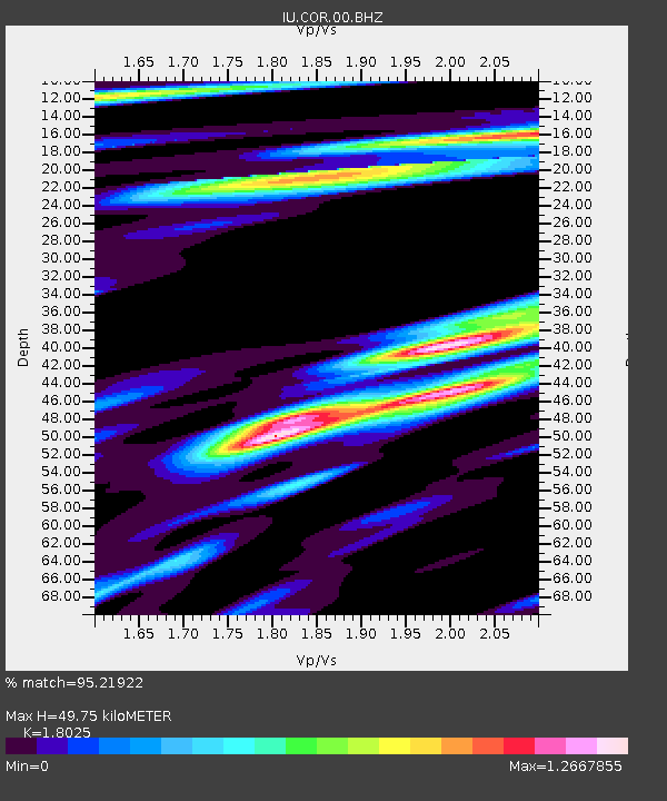
| Estimated Moho Depth: |
49.75 km |
| Estimated Crust Vp/Vs: |
1.80 |
| Assumed Crust Vp: |
6.566 km/s |
| Estimated Crust Vs: |
3.643 km/s |
| Estimated Crust Poisson's Ratio: |
0.28 |
|
| Radial Match: |
95.21922 % |
| Radial Bump: |
400 |
| Transverse Match: |
88.62228 % |
| Transverse Bump: |
400 |
| SOD ConfigId: |
1475611 |
| Insert Time: |
2016-05-01 00:07:26.043 +0000 |
| GWidth: |
2.5 |
| Max Bumps: |
400 |
| Tol: |
0.001 |
|
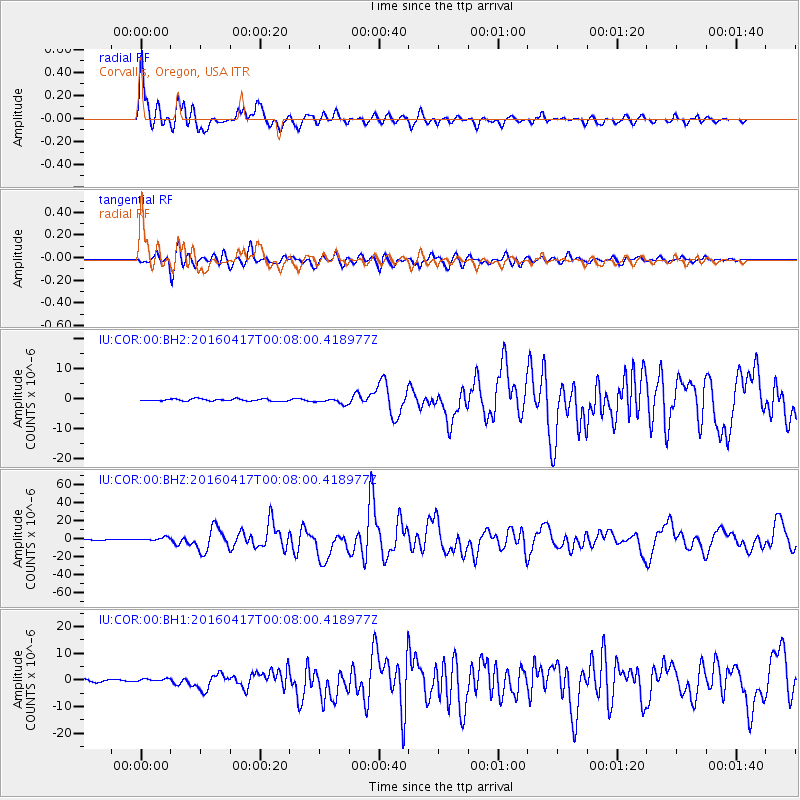
Signal To Noise
| Channel | StoN | STA | LTA |
| IU:COR:00:BHZ:20160417T00:08:00.418977Z | 4.2987356 | 1.908595E-6 | 4.4398988E-7 |
| IU:COR:00:BH1:20160417T00:08:00.418977Z | 1.768039 | 5.974484E-7 | 3.3791582E-7 |
| IU:COR:00:BH2:20160417T00:08:00.418977Z | 2.6119764 | 9.183557E-7 | 3.5159417E-7 |
| Arrivals |
| Ps | 6.4 SECOND |
| PpPs | 20 SECOND |
| PsPs/PpSs | 27 SECOND |


