You are here: Home > Network List > N4 - Central and EAstern US Network Stations List
> Station T35B Sooner Cattle Company, Foraker, OK, USA > Earthquake Result Viewer
T35B Sooner Cattle Company, Foraker, OK, USA - Earthquake Result Viewer
| Earthquake location: |
Near Coast Of Peru |
| Earthquake latitude/longitude: |
-15.8/-74.7 |
| Earthquake time(UTC): |
2018/01/14 (014) 09:18:45 GMT |
| Earthquake Depth: |
36 km |
| Earthquake Magnitude: |
7.1 mww |
| Earthquake Catalog/Contributor: |
NEIC PDE/us |
|
| Network: |
N4 Central and EAstern US Network |
| Station: |
T35B Sooner Cattle Company, Foraker, OK, USA |
| Lat/Lon: |
36.92 N/96.51 W |
| Elevation: |
413 m |
|
| Distance: |
56.3 deg |
| Az: |
339.066 deg |
| Baz: |
154.581 deg |
| Ray Param: |
0.064171255 |
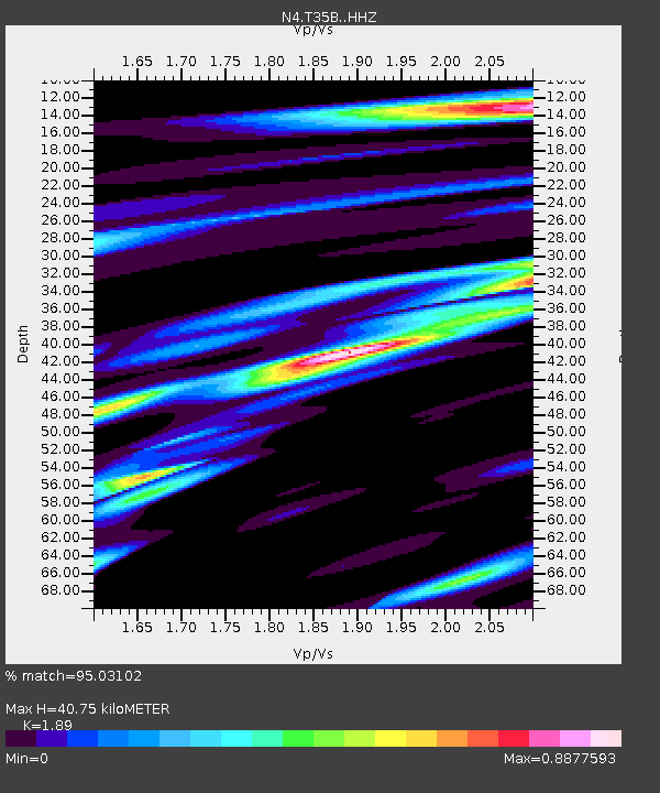
| Estimated Moho Depth: |
40.75 km |
| Estimated Crust Vp/Vs: |
1.89 |
| Assumed Crust Vp: |
6.483 km/s |
| Estimated Crust Vs: |
3.43 km/s |
| Estimated Crust Poisson's Ratio: |
0.31 |
|
| Radial Match: |
95.03102 % |
| Radial Bump: |
316 |
| Transverse Match: |
80.45736 % |
| Transverse Bump: |
400 |
| SOD ConfigId: |
13570011 |
| Insert Time: |
2019-04-29 13:40:15.604 +0000 |
| GWidth: |
2.5 |
| Max Bumps: |
400 |
| Tol: |
0.001 |
|

Signal To Noise
| Channel | StoN | STA | LTA |
| N4:T35B: :HHZ:20180114T09:27:51.539971Z | 69.10718 | 2.1392856E-5 | 3.0956053E-7 |
| N4:T35B: :HHN:20180114T09:27:51.539971Z | 45.058086 | 1.2022624E-5 | 2.6682503E-7 |
| N4:T35B: :HHE:20180114T09:27:51.539971Z | 20.107958 | 5.217455E-6 | 2.5947216E-7 |
| Arrivals |
| Ps | 5.9 SECOND |
| PpPs | 17 SECOND |
| PsPs/PpSs | 23 SECOND |


