You are here: Home > Network List > N4 - Central and EAstern US Network Stations List
> Station Y52A Lilburn, GA, USA > Earthquake Result Viewer
Y52A Lilburn, GA, USA - Earthquake Result Viewer
| Earthquake location: |
Near Coast Of Peru |
| Earthquake latitude/longitude: |
-15.8/-74.7 |
| Earthquake time(UTC): |
2018/01/14 (014) 09:18:45 GMT |
| Earthquake Depth: |
36 km |
| Earthquake Magnitude: |
7.1 mww |
| Earthquake Catalog/Contributor: |
NEIC PDE/us |
|
| Network: |
N4 Central and EAstern US Network |
| Station: |
Y52A Lilburn, GA, USA |
| Lat/Lon: |
33.86 N/84.06 W |
| Elevation: |
286 m |
|
| Distance: |
50.2 deg |
| Az: |
349.893 deg |
| Baz: |
168.284 deg |
| Ray Param: |
0.06817075 |
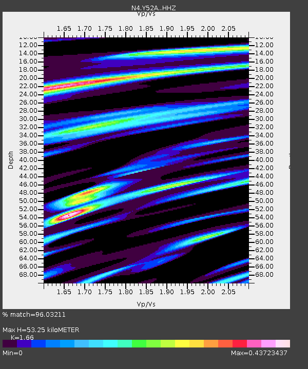
| Estimated Moho Depth: |
53.25 km |
| Estimated Crust Vp/Vs: |
1.66 |
| Assumed Crust Vp: |
6.719 km/s |
| Estimated Crust Vs: |
4.048 km/s |
| Estimated Crust Poisson's Ratio: |
0.22 |
|
| Radial Match: |
96.03211 % |
| Radial Bump: |
314 |
| Transverse Match: |
79.93717 % |
| Transverse Bump: |
400 |
| SOD ConfigId: |
13570011 |
| Insert Time: |
2019-04-29 13:40:36.742 +0000 |
| GWidth: |
2.5 |
| Max Bumps: |
400 |
| Tol: |
0.001 |
|

Signal To Noise
| Channel | StoN | STA | LTA |
| N4:Y52A: :HHZ:20180114T09:27:06.499993Z | 22.229927 | 1.3571027E-5 | 6.1048456E-7 |
| N4:Y52A: :HHN:20180114T09:27:06.499993Z | 24.93385 | 7.3263554E-6 | 2.938317E-7 |
| N4:Y52A: :HHE:20180114T09:27:06.499993Z | 3.9681907 | 1.7843503E-6 | 4.4966345E-7 |
| Arrivals |
| Ps | 5.6 SECOND |
| PpPs | 20 SECOND |
| PsPs/PpSs | 25 SECOND |


