You are here: Home > Network List > NN - Western Great Basin/Eastern Sierra Nevada Stations List
> Station MOHS Mojave High School, LLNL/ANSS BB+SM w84gm > Earthquake Result Viewer
MOHS Mojave High School, LLNL/ANSS BB+SM w84gm - Earthquake Result Viewer
| Earthquake location: |
Near Coast Of Peru |
| Earthquake latitude/longitude: |
-15.8/-74.7 |
| Earthquake time(UTC): |
2018/01/14 (014) 09:18:45 GMT |
| Earthquake Depth: |
36 km |
| Earthquake Magnitude: |
7.1 mww |
| Earthquake Catalog/Contributor: |
NEIC PDE/us |
|
| Network: |
NN Western Great Basin/Eastern Sierra Nevada |
| Station: |
MOHS Mojave High School, LLNL/ANSS BB+SM w84gm |
| Lat/Lon: |
36.25 N/115.14 W |
| Elevation: |
623 m |
|
| Distance: |
64.3 deg |
| Az: |
324.458 deg |
| Baz: |
136.178 deg |
| Ray Param: |
0.058947228 |
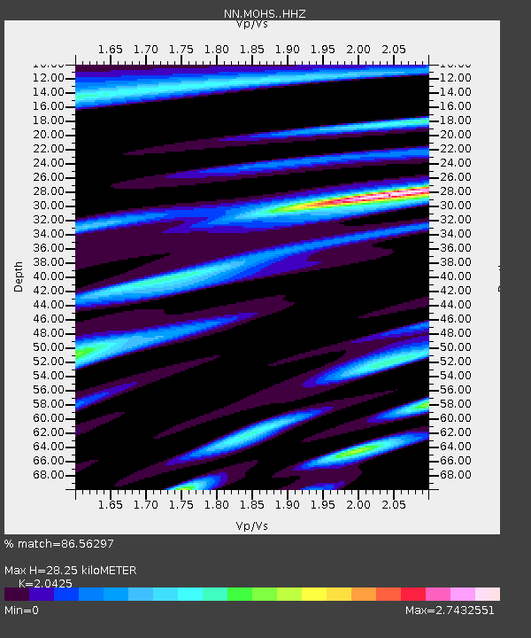
| Estimated Moho Depth: |
28.25 km |
| Estimated Crust Vp/Vs: |
2.04 |
| Assumed Crust Vp: |
6.276 km/s |
| Estimated Crust Vs: |
3.073 km/s |
| Estimated Crust Poisson's Ratio: |
0.34 |
|
| Radial Match: |
86.56297 % |
| Radial Bump: |
400 |
| Transverse Match: |
73.83265 % |
| Transverse Bump: |
400 |
| SOD ConfigId: |
13570011 |
| Insert Time: |
2019-04-29 13:40:59.945 +0000 |
| GWidth: |
2.5 |
| Max Bumps: |
400 |
| Tol: |
0.001 |
|

Signal To Noise
| Channel | StoN | STA | LTA |
| NN:MOHS: :HHZ:20180114T09:28:46.275017Z | 10.149857 | 3.5590192E-6 | 3.5064724E-7 |
| NN:MOHS: :HHN:20180114T09:28:46.275017Z | 4.6867514 | 1.8715172E-6 | 3.9932075E-7 |
| NN:MOHS: :HHE:20180114T09:28:46.275017Z | 3.1835413 | 1.4347186E-6 | 4.506675E-7 |
| Arrivals |
| Ps | 4.9 SECOND |
| PpPs | 13 SECOND |
| PsPs/PpSs | 18 SECOND |


