You are here: Home > Network List > NN - Western Great Basin/Eastern Sierra Nevada Stations List
> Station S11A Rachel, NV, USA - NN reactivation > Earthquake Result Viewer
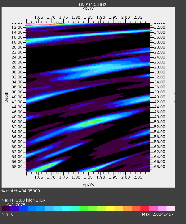
S11A Rachel, NV, USA - NN reactivation - Earthquake Result Viewer
| Earthquake location: |
Near Coast Of Peru |
| Earthquake latitude/longitude: |
-15.8/-74.7 |
| Earthquake time(UTC): |
2018/01/14 (014) 09:18:45 GMT |
| Earthquake Depth: |
36 km |
| Earthquake Magnitude: |
7.1 mww |
| Earthquake Catalog/Contributor: |
NEIC PDE/us |
|
| Network: |
NN Western Great Basin/Eastern Sierra Nevada |
| Station: |
S11A Rachel, NV, USA - NN reactivation |
| Lat/Lon: |
37.64 N/115.75 W |
| Elevation: |
1456 m |
|
| Distance: |
65.6 deg |
| Az: |
325.131 deg |
| Baz: |
136.098 deg |
| Ray Param: |
0.058076885 |
| Estimated Moho Depth: |
10.0 km |
| Estimated Crust Vp/Vs: |
1.71 |
| Assumed Crust Vp: |
6.276 km/s |
| Estimated Crust Vs: |
3.675 km/s |
| Estimated Crust Poisson's Ratio: |
0.24 |
|
| Radial Match: |
84.85808 % |
| Radial Bump: |
400 |
| Transverse Match: |
78.20151 % |
| Transverse Bump: |
400 |
| SOD ConfigId: |
13570011 |
| Insert Time: |
2019-04-29 13:41:12.498 +0000 |
| GWidth: |
2.5 |
| Max Bumps: |
400 |
| Tol: |
0.001 |
|

Signal To Noise
| Channel | StoN | STA | LTA |
| NN:S11A: :HHZ:20180114T09:28:54.947991Z | 20.651772 | 4.878839E-6 | 2.3624312E-7 |
| NN:S11A: :HHN:20180114T09:28:54.947991Z | 4.6889963 | 8.819046E-7 | 1.8807961E-7 |
| NN:S11A: :HHE:20180114T09:28:54.947991Z | 3.723804 | 1.229585E-6 | 3.3019595E-7 |
| Arrivals |
| Ps | 1.2 SECOND |
| PpPs | 4.1 SECOND |
| PsPs/PpSs | 5.3 SECOND |


