You are here: Home > Network List > NR - NARS Array Stations List
> Station NE204 Xaudum > Earthquake Result Viewer
NE204 Xaudum - Earthquake Result Viewer
| Earthquake location: |
Near Coast Of Peru |
| Earthquake latitude/longitude: |
-15.8/-74.7 |
| Earthquake time(UTC): |
2018/01/14 (014) 09:18:45 GMT |
| Earthquake Depth: |
36 km |
| Earthquake Magnitude: |
7.1 mww |
| Earthquake Catalog/Contributor: |
NEIC PDE/us |
|
| Network: |
NR NARS Array |
| Station: |
NE204 Xaudum |
| Lat/Lon: |
18.54 S/21.34 E |
| Elevation: |
1060 m |
|
| Distance: |
90.7 deg |
| Az: |
109.358 deg |
| Baz: |
253.226 deg |
| Ray Param: |
0.041653417 |
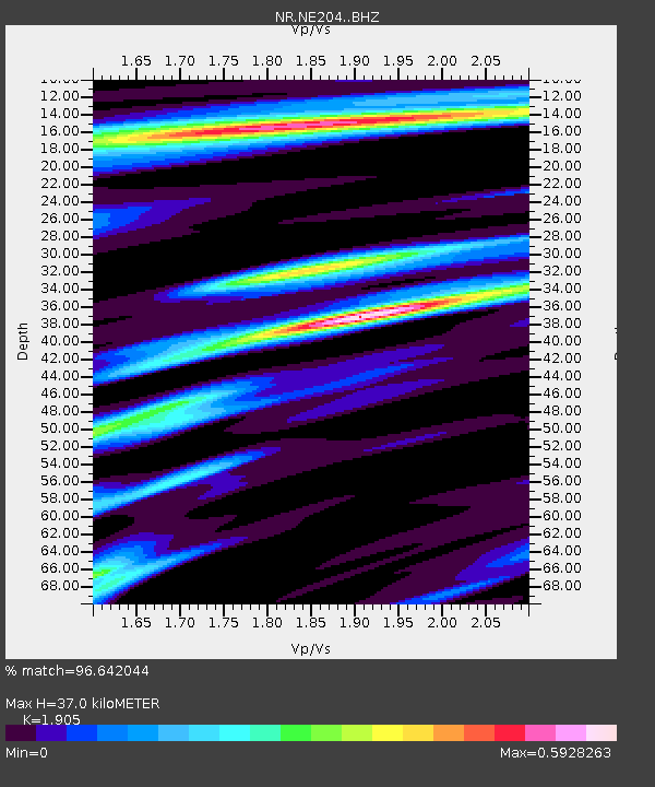
| Estimated Moho Depth: |
37.0 km |
| Estimated Crust Vp/Vs: |
1.90 |
| Assumed Crust Vp: |
6.577 km/s |
| Estimated Crust Vs: |
3.452 km/s |
| Estimated Crust Poisson's Ratio: |
0.31 |
|
| Radial Match: |
96.642044 % |
| Radial Bump: |
400 |
| Transverse Match: |
91.50554 % |
| Transverse Bump: |
400 |
| SOD ConfigId: |
13570011 |
| Insert Time: |
2019-04-29 13:41:22.743 +0000 |
| GWidth: |
2.5 |
| Max Bumps: |
400 |
| Tol: |
0.001 |
|

Signal To Noise
| Channel | StoN | STA | LTA |
| NR:NE204: :BHZ:20180114T09:31:12.614983Z | 18.164816 | 3.2310195E-6 | 1.7787241E-7 |
| NR:NE204: :BHN:20180114T09:31:12.614983Z | 2.0833652 | 3.3883003E-7 | 1.6263593E-7 |
| NR:NE204: :BHE:20180114T09:31:12.614983Z | 4.4136724 | 9.711727E-7 | 2.2003732E-7 |
| Arrivals |
| Ps | 5.2 SECOND |
| PpPs | 16 SECOND |
| PsPs/PpSs | 21 SECOND |


