You are here: Home > Network List > OH - Ohio Seismic Network Stations List
> Station LEBO Lake Erie Bluffs Ohio > Earthquake Result Viewer
LEBO Lake Erie Bluffs Ohio - Earthquake Result Viewer
| Earthquake location: |
Near Coast Of Peru |
| Earthquake latitude/longitude: |
-15.8/-74.7 |
| Earthquake time(UTC): |
2018/01/14 (014) 09:18:45 GMT |
| Earthquake Depth: |
36 km |
| Earthquake Magnitude: |
7.1 mww |
| Earthquake Catalog/Contributor: |
NEIC PDE/us |
|
| Network: |
OH Ohio Seismic Network |
| Station: |
LEBO Lake Erie Bluffs Ohio |
| Lat/Lon: |
41.79 N/81.18 W |
| Elevation: |
188 m |
|
| Distance: |
57.6 deg |
| Az: |
354.301 deg |
| Baz: |
172.654 deg |
| Ray Param: |
0.063334875 |
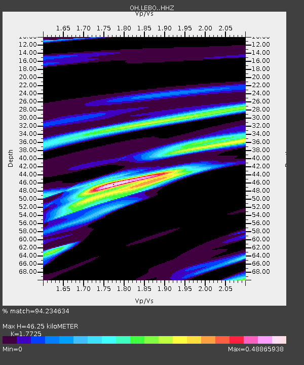
| Estimated Moho Depth: |
46.25 km |
| Estimated Crust Vp/Vs: |
1.77 |
| Assumed Crust Vp: |
6.483 km/s |
| Estimated Crust Vs: |
3.657 km/s |
| Estimated Crust Poisson's Ratio: |
0.27 |
|
| Radial Match: |
94.234634 % |
| Radial Bump: |
266 |
| Transverse Match: |
69.47216 % |
| Transverse Bump: |
400 |
| SOD ConfigId: |
13570011 |
| Insert Time: |
2019-04-29 13:41:42.468 +0000 |
| GWidth: |
2.5 |
| Max Bumps: |
400 |
| Tol: |
0.001 |
|

Signal To Noise
| Channel | StoN | STA | LTA |
| OH:LEBO: :HHZ:20180114T09:28:00.59002Z | 18.863064 | 1.2320828E-5 | 6.5317215E-7 |
| OH:LEBO: :HHN:20180114T09:28:00.59002Z | 14.853043 | 6.3266248E-6 | 4.259481E-7 |
| OH:LEBO: :HHE:20180114T09:28:00.59002Z | 2.264349 | 1.0886708E-6 | 4.807876E-7 |
| Arrivals |
| Ps | 5.8 SECOND |
| PpPs | 19 SECOND |
| PsPs/PpSs | 25 SECOND |


