You are here: Home > Network List > OK - Oklahoma Seismic Network Stations List
> Station MOOR Moore, Oklahoma, USA > Earthquake Result Viewer
MOOR Moore, Oklahoma, USA - Earthquake Result Viewer
| Earthquake location: |
Near Coast Of Peru |
| Earthquake latitude/longitude: |
-15.8/-74.7 |
| Earthquake time(UTC): |
2018/01/14 (014) 09:18:45 GMT |
| Earthquake Depth: |
36 km |
| Earthquake Magnitude: |
7.1 mww |
| Earthquake Catalog/Contributor: |
NEIC PDE/us |
|
| Network: |
OK Oklahoma Seismic Network |
| Station: |
MOOR Moore, Oklahoma, USA |
| Lat/Lon: |
35.34 N/97.66 W |
| Elevation: |
371 m |
|
| Distance: |
55.3 deg |
| Az: |
337.217 deg |
| Baz: |
152.868 deg |
| Ray Param: |
0.06482012 |
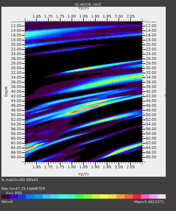
| Estimated Moho Depth: |
47.25 km |
| Estimated Crust Vp/Vs: |
1.86 |
| Assumed Crust Vp: |
6.426 km/s |
| Estimated Crust Vs: |
3.464 km/s |
| Estimated Crust Poisson's Ratio: |
0.30 |
|
| Radial Match: |
90.86543 % |
| Radial Bump: |
344 |
| Transverse Match: |
81.18122 % |
| Transverse Bump: |
400 |
| SOD ConfigId: |
13570011 |
| Insert Time: |
2019-04-29 13:41:51.694 +0000 |
| GWidth: |
2.5 |
| Max Bumps: |
400 |
| Tol: |
0.001 |
|

Signal To Noise
| Channel | StoN | STA | LTA |
| OK:MOOR: :HHZ:20180114T09:27:44.418999Z | 34.64887 | 1.44700225E-5 | 4.1761888E-7 |
| OK:MOOR: :HHN:20180114T09:27:44.418999Z | 7.6552863 | 4.9325217E-6 | 6.4432885E-7 |
| OK:MOOR: :HHE:20180114T09:27:44.418999Z | 4.374621 | 2.6388855E-6 | 6.0322606E-7 |
| Arrivals |
| Ps | 6.6 SECOND |
| PpPs | 20 SECOND |
| PsPs/PpSs | 27 SECOND |


