You are here: Home > Network List > ON - RSIS-Rede Sismografica do Sul e Sudeste Observatorio Nacional, Brazil Stations List
> Station GUA01 "OBSN: [GUA01] Guaratinga, BA" > Earthquake Result Viewer
GUA01 "OBSN: [GUA01] Guaratinga, BA" - Earthquake Result Viewer
| Earthquake location: |
Near Coast Of Peru |
| Earthquake latitude/longitude: |
-15.8/-74.7 |
| Earthquake time(UTC): |
2018/01/14 (014) 09:18:45 GMT |
| Earthquake Depth: |
36 km |
| Earthquake Magnitude: |
7.1 mww |
| Earthquake Catalog/Contributor: |
NEIC PDE/us |
|
| Network: |
ON RSIS-Rede Sismografica do Sul e Sudeste Observatorio Nacional, Brazil |
| Station: |
GUA01 "OBSN: [GUA01] Guaratinga, BA" |
| Lat/Lon: |
16.58 S/39.81 W |
| Elevation: |
198 m |
|
| Distance: |
33.5 deg |
| Az: |
96.309 deg |
| Baz: |
266.347 deg |
| Ray Param: |
0.07809808 |
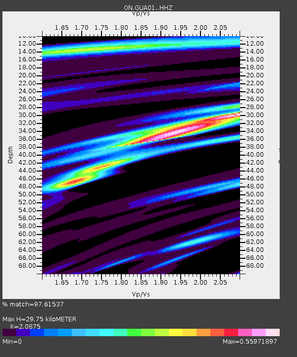
| Estimated Moho Depth: |
29.75 km |
| Estimated Crust Vp/Vs: |
2.09 |
| Assumed Crust Vp: |
6.391 km/s |
| Estimated Crust Vs: |
3.061 km/s |
| Estimated Crust Poisson's Ratio: |
0.35 |
|
| Radial Match: |
97.61537 % |
| Radial Bump: |
316 |
| Transverse Match: |
93.4256 % |
| Transverse Bump: |
400 |
| SOD ConfigId: |
13570011 |
| Insert Time: |
2019-04-29 13:41:59.381 +0000 |
| GWidth: |
2.5 |
| Max Bumps: |
400 |
| Tol: |
0.001 |
|

Signal To Noise
| Channel | StoN | STA | LTA |
| ON:GUA01: :HHZ:20180114T09:24:51.017998Z | 148.84595 | 2.0888427E-5 | 1.4033589E-7 |
| ON:GUA01: :HHN:20180114T09:24:51.017998Z | 10.336779 | 8.9546523E-7 | 8.662905E-8 |
| ON:GUA01: :HHE:20180114T09:24:51.017998Z | 159.01466 | 1.3935001E-5 | 8.763344E-8 |
| Arrivals |
| Ps | 5.4 SECOND |
| PpPs | 13 SECOND |
| PsPs/PpSs | 19 SECOND |


