You are here: Home > Network List > PE - Penn State Network Stations List
> Station PABK Blue Knob State Park, Imler, PA > Earthquake Result Viewer
PABK Blue Knob State Park, Imler, PA - Earthquake Result Viewer
| Earthquake location: |
Near Coast Of Peru |
| Earthquake latitude/longitude: |
-15.8/-74.7 |
| Earthquake time(UTC): |
2018/01/14 (014) 09:18:45 GMT |
| Earthquake Depth: |
36 km |
| Earthquake Magnitude: |
7.1 mww |
| Earthquake Catalog/Contributor: |
NEIC PDE/us |
|
| Network: |
PE Penn State Network |
| Station: |
PABK Blue Knob State Park, Imler, PA |
| Lat/Lon: |
40.27 N/78.58 W |
| Elevation: |
482 m |
|
| Distance: |
55.9 deg |
| Az: |
356.451 deg |
| Baz: |
175.533 deg |
| Ray Param: |
0.064444855 |
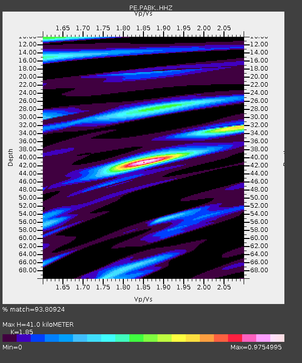
| Estimated Moho Depth: |
41.0 km |
| Estimated Crust Vp/Vs: |
1.85 |
| Assumed Crust Vp: |
6.121 km/s |
| Estimated Crust Vs: |
3.308 km/s |
| Estimated Crust Poisson's Ratio: |
0.29 |
|
| Radial Match: |
93.80924 % |
| Radial Bump: |
377 |
| Transverse Match: |
90.63602 % |
| Transverse Bump: |
400 |
| SOD ConfigId: |
13570011 |
| Insert Time: |
2019-04-29 13:42:08.392 +0000 |
| GWidth: |
2.5 |
| Max Bumps: |
400 |
| Tol: |
0.001 |
|

Signal To Noise
| Channel | StoN | STA | LTA |
| PE:PABK: :HHZ:20180114T09:27:48.46502Z | 27.219177 | 6.117924E-5 | 2.2476522E-6 |
| PE:PABK: :HHN:20180114T09:27:48.46502Z | 16.19161 | 2.4695119E-5 | 1.52518E-6 |
| PE:PABK: :HHE:20180114T09:27:48.46502Z | 1.2697278 | 2.8588374E-6 | 2.2515358E-6 |
| Arrivals |
| Ps | 6.0 SECOND |
| PpPs | 18 SECOND |
| PsPs/PpSs | 24 SECOND |


