You are here: Home > Network List > PR - Puerto Rico Seismic Network (PRSN) & Puerto Rico Strong Motion Program (PRSMP) Stations List
> Station PRSN PRSN_RUM > Earthquake Result Viewer
PRSN PRSN_RUM - Earthquake Result Viewer
| Earthquake location: |
Near Coast Of Peru |
| Earthquake latitude/longitude: |
-15.8/-74.7 |
| Earthquake time(UTC): |
2018/01/14 (014) 09:18:45 GMT |
| Earthquake Depth: |
36 km |
| Earthquake Magnitude: |
7.1 mww |
| Earthquake Catalog/Contributor: |
NEIC PDE/us |
|
| Network: |
PR Puerto Rico Seismic Network (PRSN) & Puerto Rico Strong Motion Program (PRSMP) |
| Station: |
PRSN PRSN_RUM |
| Lat/Lon: |
18.22 N/67.14 W |
| Elevation: |
27 m |
|
| Distance: |
34.6 deg |
| Az: |
12.79 deg |
| Baz: |
192.958 deg |
| Ray Param: |
0.0775895 |
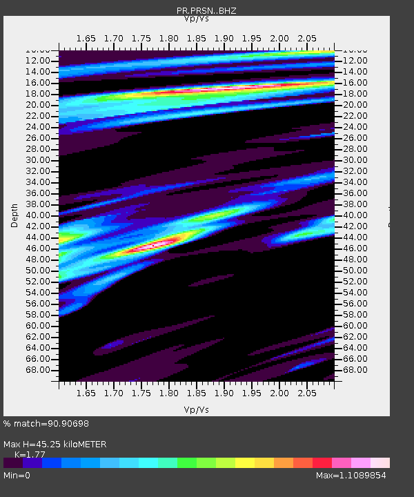
| Estimated Moho Depth: |
45.25 km |
| Estimated Crust Vp/Vs: |
1.77 |
| Assumed Crust Vp: |
5.14 km/s |
| Estimated Crust Vs: |
2.904 km/s |
| Estimated Crust Poisson's Ratio: |
0.27 |
|
| Radial Match: |
90.90698 % |
| Radial Bump: |
400 |
| Transverse Match: |
84.430305 % |
| Transverse Bump: |
400 |
| SOD ConfigId: |
13570011 |
| Insert Time: |
2019-04-29 13:42:45.699 +0000 |
| GWidth: |
2.5 |
| Max Bumps: |
400 |
| Tol: |
0.001 |
|

Signal To Noise
| Channel | StoN | STA | LTA |
| PR:PRSN: :BHZ:20180114T09:25:00.240013Z | 28.240427 | 8.416115E-6 | 2.9801657E-7 |
| PR:PRSN: :BHN:20180114T09:25:00.240013Z | 21.258844 | 4.2410093E-6 | 1.9949387E-7 |
| PR:PRSN: :BHE:20180114T09:25:00.240013Z | 2.7590044 | 8.8210055E-7 | 3.19717E-7 |
| Arrivals |
| Ps | 7.1 SECOND |
| PpPs | 23 SECOND |
| PsPs/PpSs | 30 SECOND |


