You are here: Home > Network List > RV - Regional Alberta Seismic Observatory for Earthquake Studies Network Stations List
> Station KIMIA Kimiwan Lookout Tower, AB > Earthquake Result Viewer
KIMIA Kimiwan Lookout Tower, AB - Earthquake Result Viewer
| Earthquake location: |
Near Coast Of Peru |
| Earthquake latitude/longitude: |
-15.8/-74.7 |
| Earthquake time(UTC): |
2018/01/14 (014) 09:18:45 GMT |
| Earthquake Depth: |
36 km |
| Earthquake Magnitude: |
7.1 mww |
| Earthquake Catalog/Contributor: |
NEIC PDE/us |
|
| Network: |
RV Regional Alberta Seismic Observatory for Earthquake Studies Network |
| Station: |
KIMIA Kimiwan Lookout Tower, AB |
| Lat/Lon: |
55.99 N/116.61 W |
| Elevation: |
764 m |
|
| Distance: |
79.7 deg |
| Az: |
337.595 deg |
| Baz: |
139.222 deg |
| Ray Param: |
0.048751317 |
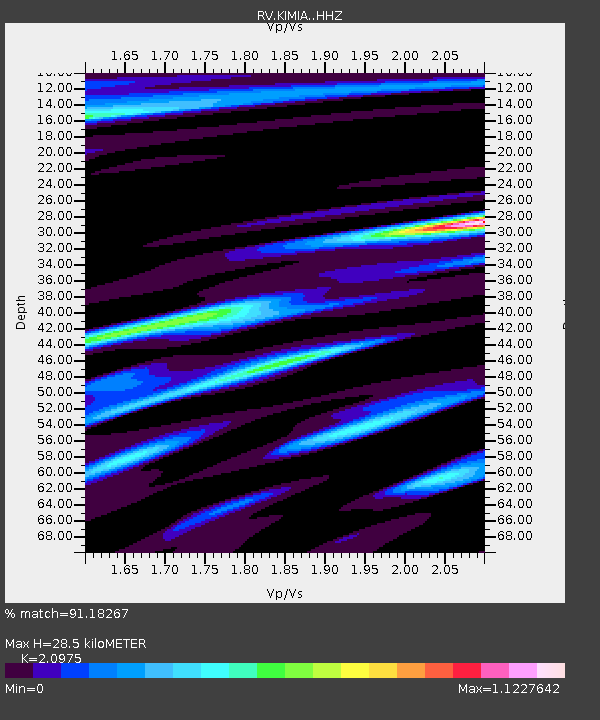
| Estimated Moho Depth: |
28.5 km |
| Estimated Crust Vp/Vs: |
2.10 |
| Assumed Crust Vp: |
6.426 km/s |
| Estimated Crust Vs: |
3.064 km/s |
| Estimated Crust Poisson's Ratio: |
0.35 |
|
| Radial Match: |
91.18267 % |
| Radial Bump: |
255 |
| Transverse Match: |
80.96534 % |
| Transverse Bump: |
332 |
| SOD ConfigId: |
13570011 |
| Insert Time: |
2019-04-29 13:43:07.811 +0000 |
| GWidth: |
2.5 |
| Max Bumps: |
400 |
| Tol: |
0.001 |
|

Signal To Noise
| Channel | StoN | STA | LTA |
| RV:KIMIA: :HHZ:20180114T09:30:17.960015Z | 29.344765 | 1.6836138E-5 | 5.737357E-7 |
| RV:KIMIA: :HHN:20180114T09:30:17.960015Z | 4.8034644 | 4.751761E-6 | 9.892362E-7 |
| RV:KIMIA: :HHE:20180114T09:30:17.960015Z | 4.554301 | 4.410861E-6 | 9.685045E-7 |
| Arrivals |
| Ps | 5.0 SECOND |
| PpPs | 13 SECOND |
| PsPs/PpSs | 18 SECOND |


