You are here: Home > Network List > SV - Servicio Nacional de Estudios Territoriales (SNET), El Salvador Stations List
> Station SNET Servicio Nacional de Estudios Territoriales, El Salvador > Earthquake Result Viewer
SNET Servicio Nacional de Estudios Territoriales, El Salvador - Earthquake Result Viewer
| Earthquake location: |
Near Coast Of Peru |
| Earthquake latitude/longitude: |
-15.8/-74.7 |
| Earthquake time(UTC): |
2018/01/14 (014) 09:18:45 GMT |
| Earthquake Depth: |
36 km |
| Earthquake Magnitude: |
7.1 mww |
| Earthquake Catalog/Contributor: |
NEIC PDE/us |
|
| Network: |
SV Servicio Nacional de Estudios Territoriales (SNET), El Salvador |
| Station: |
SNET Servicio Nacional de Estudios Territoriales, El Salvador |
| Lat/Lon: |
13.69 N/89.23 W |
| Elevation: |
775 m |
|
| Distance: |
32.6 deg |
| Az: |
333.165 deg |
| Baz: |
153.438 deg |
| Ray Param: |
0.07852855 |
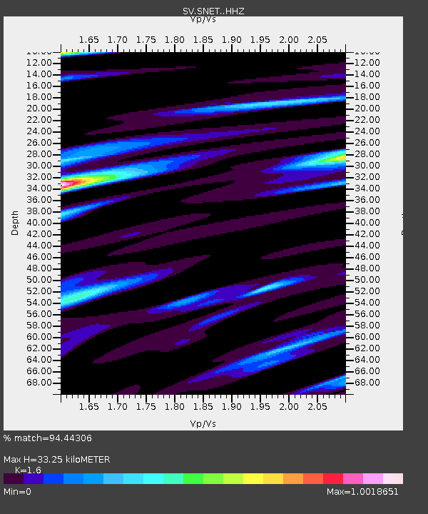
| Estimated Moho Depth: |
33.25 km |
| Estimated Crust Vp/Vs: |
1.60 |
| Assumed Crust Vp: |
6.048 km/s |
| Estimated Crust Vs: |
3.78 km/s |
| Estimated Crust Poisson's Ratio: |
0.18 |
|
| Radial Match: |
94.44306 % |
| Radial Bump: |
307 |
| Transverse Match: |
88.11735 % |
| Transverse Bump: |
400 |
| SOD ConfigId: |
13570011 |
| Insert Time: |
2019-04-29 13:43:21.988 +0000 |
| GWidth: |
2.5 |
| Max Bumps: |
400 |
| Tol: |
0.001 |
|

Signal To Noise
| Channel | StoN | STA | LTA |
| SV:SNET: :HHZ:20180114T09:24:43.028008Z | 11.047405 | 5.8561245E-6 | 5.300905E-7 |
| SV:SNET: :HHN:20180114T09:24:43.028008Z | 4.1863675 | 3.7668194E-6 | 8.997823E-7 |
| SV:SNET: :HHE:20180114T09:24:43.028008Z | 1.5172917 | 1.2942212E-6 | 8.5298115E-7 |
| Arrivals |
| Ps | 3.6 SECOND |
| PpPs | 13 SECOND |
| PsPs/PpSs | 17 SECOND |


