You are here: Home > Network List > TA - USArray Transportable Network (new EarthScope stations) Stations List
> Station D27M Malcolm River, YT, CAN > Earthquake Result Viewer
D27M Malcolm River, YT, CAN - Earthquake Result Viewer
| Earthquake location: |
Near Coast Of Peru |
| Earthquake latitude/longitude: |
-15.8/-74.7 |
| Earthquake time(UTC): |
2018/01/14 (014) 09:18:45 GMT |
| Earthquake Depth: |
36 km |
| Earthquake Magnitude: |
7.1 mww |
| Earthquake Catalog/Contributor: |
NEIC PDE/us |
|
| Network: |
TA USArray Transportable Network (new EarthScope stations) |
| Station: |
D27M Malcolm River, YT, CAN |
| Lat/Lon: |
69.24 N/140.96 W |
| Elevation: |
896 m |
|
| Distance: |
96.5 deg |
| Az: |
340.83 deg |
| Baz: |
117.519 deg |
| Ray Param: |
0.04046365 |
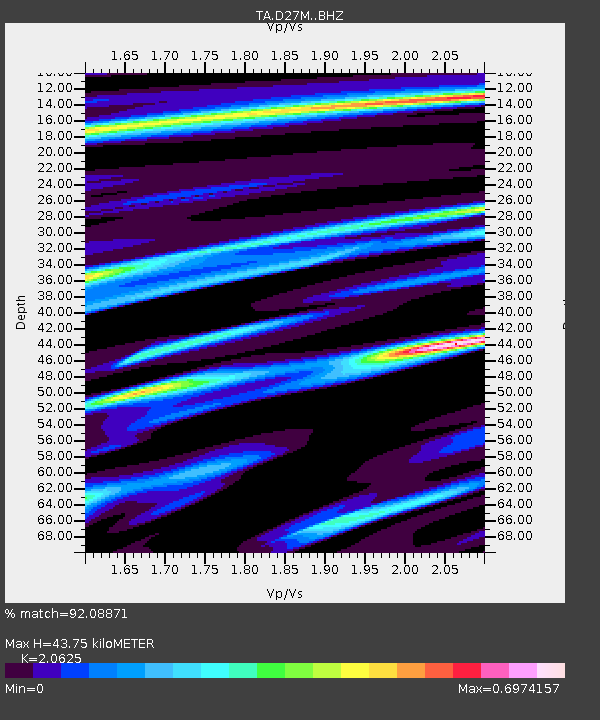
| Estimated Moho Depth: |
43.75 km |
| Estimated Crust Vp/Vs: |
2.06 |
| Assumed Crust Vp: |
6.522 km/s |
| Estimated Crust Vs: |
3.162 km/s |
| Estimated Crust Poisson's Ratio: |
0.35 |
|
| Radial Match: |
92.08871 % |
| Radial Bump: |
319 |
| Transverse Match: |
78.27549 % |
| Transverse Bump: |
400 |
| SOD ConfigId: |
13570011 |
| Insert Time: |
2019-04-29 13:43:30.474 +0000 |
| GWidth: |
2.5 |
| Max Bumps: |
400 |
| Tol: |
0.001 |
|

Signal To Noise
| Channel | StoN | STA | LTA |
| TA:D27M: :BHZ:20180114T09:31:39.650017Z | 19.524654 | 3.950576E-6 | 2.023378E-7 |
| TA:D27M: :BHN:20180114T09:31:39.650017Z | 2.235888 | 4.1241873E-7 | 1.8445411E-7 |
| TA:D27M: :BHE:20180114T09:31:39.650017Z | 5.6858826 | 1.3185422E-6 | 2.3189753E-7 |
| Arrivals |
| Ps | 7.3 SECOND |
| PpPs | 20 SECOND |
| PsPs/PpSs | 27 SECOND |


