You are here: Home > Network List > TA - USArray Transportable Network (new EarthScope stations) Stations List
> Station E27K Coleen River, AK, USA > Earthquake Result Viewer
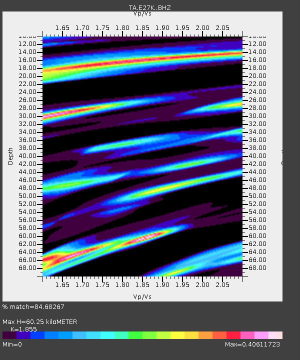
E27K Coleen River, AK, USA - Earthquake Result Viewer
| Earthquake location: |
Near Coast Of Peru |
| Earthquake latitude/longitude: |
-15.8/-74.7 |
| Earthquake time(UTC): |
2018/01/14 (014) 09:18:45 GMT |
| Earthquake Depth: |
36 km |
| Earthquake Magnitude: |
7.1 mww |
| Earthquake Catalog/Contributor: |
NEIC PDE/us |
|
| Network: |
TA USArray Transportable Network (new EarthScope stations) |
| Station: |
E27K Coleen River, AK, USA |
| Lat/Lon: |
68.19 N/141.60 W |
| Elevation: |
654 m |
|
| Distance: |
96.3 deg |
| Az: |
339.774 deg |
| Baz: |
117.05 deg |
| Ray Param: |
0.040545765 |
| Estimated Moho Depth: |
60.25 km |
| Estimated Crust Vp/Vs: |
1.86 |
| Assumed Crust Vp: |
6.522 km/s |
| Estimated Crust Vs: |
3.516 km/s |
| Estimated Crust Poisson's Ratio: |
0.30 |
|
| Radial Match: |
84.68267 % |
| Radial Bump: |
400 |
| Transverse Match: |
62.81436 % |
| Transverse Bump: |
400 |
| SOD ConfigId: |
13570011 |
| Insert Time: |
2019-04-29 13:43:32.190 +0000 |
| GWidth: |
2.5 |
| Max Bumps: |
400 |
| Tol: |
0.001 |
|

Signal To Noise
| Channel | StoN | STA | LTA |
| TA:E27K: :BHZ:20180114T09:31:38.374993Z | 10.315916 | 3.964974E-6 | 3.8435502E-7 |
| TA:E27K: :BHN:20180114T09:31:38.374993Z | 1.2066385 | 5.15825E-7 | 4.2748925E-7 |
| TA:E27K: :BHE:20180114T09:31:38.374993Z | 4.668607 | 1.2807852E-6 | 2.743399E-7 |
| Arrivals |
| Ps | 8.1 SECOND |
| PpPs | 26 SECOND |
| PsPs/PpSs | 34 SECOND |


