You are here: Home > Network List > TA - USArray Transportable Network (new EarthScope stations) Stations List
> Station E29M Blow River, YT, CAN > Earthquake Result Viewer
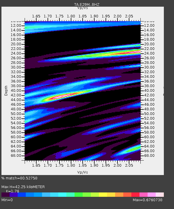
E29M Blow River, YT, CAN - Earthquake Result Viewer
| Earthquake location: |
Near Coast Of Peru |
| Earthquake latitude/longitude: |
-15.8/-74.7 |
| Earthquake time(UTC): |
2018/01/14 (014) 09:18:45 GMT |
| Earthquake Depth: |
36 km |
| Earthquake Magnitude: |
7.1 mww |
| Earthquake Catalog/Contributor: |
NEIC PDE/us |
|
| Network: |
TA USArray Transportable Network (new EarthScope stations) |
| Station: |
E29M Blow River, YT, CAN |
| Lat/Lon: |
68.39 N/137.90 W |
| Elevation: |
324 m |
|
| Distance: |
95.2 deg |
| Az: |
340.618 deg |
| Baz: |
120.399 deg |
| Ray Param: |
0.04084007 |
| Estimated Moho Depth: |
42.25 km |
| Estimated Crust Vp/Vs: |
1.76 |
| Assumed Crust Vp: |
5.981 km/s |
| Estimated Crust Vs: |
3.398 km/s |
| Estimated Crust Poisson's Ratio: |
0.26 |
|
| Radial Match: |
80.52758 % |
| Radial Bump: |
400 |
| Transverse Match: |
69.73087 % |
| Transverse Bump: |
400 |
| SOD ConfigId: |
13570011 |
| Insert Time: |
2019-04-29 13:43:33.064 +0000 |
| GWidth: |
2.5 |
| Max Bumps: |
400 |
| Tol: |
0.001 |
|

Signal To Noise
| Channel | StoN | STA | LTA |
| TA:E29M: :BHZ:20180114T09:31:33.374993Z | 9.212832 | 4.2132965E-6 | 4.5732912E-7 |
| TA:E29M: :BHN:20180114T09:31:33.374993Z | 2.6642215 | 9.740735E-7 | 3.656128E-7 |
| TA:E29M: :BHE:20180114T09:31:33.374993Z | 4.259068 | 1.338136E-6 | 3.1418517E-7 |
| Arrivals |
| Ps | 5.5 SECOND |
| PpPs | 19 SECOND |
| PsPs/PpSs | 25 SECOND |


