You are here: Home > Network List > TA - USArray Transportable Network (new EarthScope stations) Stations List
> Station G30M túh Zraii Njik, YT, CAN > Earthquake Result Viewer
G30M túh Zraii Njik, YT, CAN - Earthquake Result Viewer
| Earthquake location: |
Near Coast Of Peru |
| Earthquake latitude/longitude: |
-15.8/-74.7 |
| Earthquake time(UTC): |
2018/01/14 (014) 09:18:45 GMT |
| Earthquake Depth: |
36 km |
| Earthquake Magnitude: |
7.1 mww |
| Earthquake Catalog/Contributor: |
NEIC PDE/us |
|
| Network: |
TA USArray Transportable Network (new EarthScope stations) |
| Station: |
G30M túh Zraii Njik, YT, CAN |
| Lat/Lon: |
66.98 N/136.22 W |
| Elevation: |
739 m |
|
| Distance: |
93.9 deg |
| Az: |
339.737 deg |
| Baz: |
122.017 deg |
| Ray Param: |
0.041158583 |
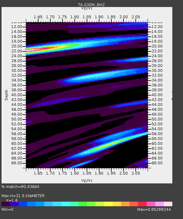
| Estimated Moho Depth: |
21.5 km |
| Estimated Crust Vp/Vs: |
1.60 |
| Assumed Crust Vp: |
6.522 km/s |
| Estimated Crust Vs: |
4.076 km/s |
| Estimated Crust Poisson's Ratio: |
0.18 |
|
| Radial Match: |
90.43664 % |
| Radial Bump: |
400 |
| Transverse Match: |
74.08749 % |
| Transverse Bump: |
400 |
| SOD ConfigId: |
13570011 |
| Insert Time: |
2019-04-29 13:43:43.408 +0000 |
| GWidth: |
2.5 |
| Max Bumps: |
400 |
| Tol: |
0.001 |
|

Signal To Noise
| Channel | StoN | STA | LTA |
| TA:G30M: :BHZ:20180114T09:31:27.54998Z | 10.778085 | 5.4060647E-6 | 5.0157934E-7 |
| TA:G30M: :BHN:20180114T09:31:27.54998Z | 1.3893187 | 4.9075675E-7 | 3.5323555E-7 |
| TA:G30M: :BHE:20180114T09:31:27.54998Z | 6.3588 | 1.8363539E-6 | 2.8878938E-7 |
| Arrivals |
| Ps | 2.0 SECOND |
| PpPs | 8.4 SECOND |
| PsPs/PpSs | 10 SECOND |


