You are here: Home > Network List > TA - USArray Transportable Network (new EarthScope stations) Stations List
> Station M29M Somme Creek, YT, CAN > Earthquake Result Viewer
M29M Somme Creek, YT, CAN - Earthquake Result Viewer
| Earthquake location: |
Near Coast Of Peru |
| Earthquake latitude/longitude: |
-15.8/-74.7 |
| Earthquake time(UTC): |
2018/01/14 (014) 09:18:45 GMT |
| Earthquake Depth: |
36 km |
| Earthquake Magnitude: |
7.1 mww |
| Earthquake Catalog/Contributor: |
NEIC PDE/us |
|
| Network: |
TA USArray Transportable Network (new EarthScope stations) |
| Station: |
M29M Somme Creek, YT, CAN |
| Lat/Lon: |
62.44 N/138.46 W |
| Elevation: |
1297 m |
|
| Distance: |
92.3 deg |
| Az: |
335.333 deg |
| Baz: |
120.231 deg |
| Ray Param: |
0.041462425 |
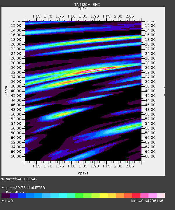
| Estimated Moho Depth: |
30.75 km |
| Estimated Crust Vp/Vs: |
1.91 |
| Assumed Crust Vp: |
6.566 km/s |
| Estimated Crust Vs: |
3.442 km/s |
| Estimated Crust Poisson's Ratio: |
0.31 |
|
| Radial Match: |
89.20547 % |
| Radial Bump: |
400 |
| Transverse Match: |
72.53402 % |
| Transverse Bump: |
400 |
| SOD ConfigId: |
13570011 |
| Insert Time: |
2019-04-29 13:44:08.105 +0000 |
| GWidth: |
2.5 |
| Max Bumps: |
400 |
| Tol: |
0.001 |
|

Signal To Noise
| Channel | StoN | STA | LTA |
| TA:M29M: :BHZ:20180114T09:31:20.525017Z | 9.288188 | 5.4180778E-6 | 5.833299E-7 |
| TA:M29M: :BHN:20180114T09:31:20.525017Z | 1.3941114 | 6.3948494E-7 | 4.5870436E-7 |
| TA:M29M: :BHE:20180114T09:31:20.525017Z | 4.700036 | 1.5679129E-6 | 3.3359595E-7 |
| Arrivals |
| Ps | 4.3 SECOND |
| PpPs | 13 SECOND |
| PsPs/PpSs | 18 SECOND |


