You are here: Home > Network List > TA - USArray Transportable Network (new EarthScope stations) Stations List
> Station MSTX Muleshoe, TX, USA > Earthquake Result Viewer
MSTX Muleshoe, TX, USA - Earthquake Result Viewer
| Earthquake location: |
Near Coast Of Peru |
| Earthquake latitude/longitude: |
-15.8/-74.7 |
| Earthquake time(UTC): |
2018/01/14 (014) 09:18:45 GMT |
| Earthquake Depth: |
36 km |
| Earthquake Magnitude: |
7.1 mww |
| Earthquake Catalog/Contributor: |
NEIC PDE/us |
|
| Network: |
TA USArray Transportable Network (new EarthScope stations) |
| Station: |
MSTX Muleshoe, TX, USA |
| Lat/Lon: |
33.97 N/102.77 W |
| Elevation: |
1167 m |
|
| Distance: |
56.2 deg |
| Az: |
331.975 deg |
| Baz: |
147.02 deg |
| Ray Param: |
0.064216726 |
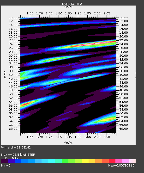
| Estimated Moho Depth: |
23.5 km |
| Estimated Crust Vp/Vs: |
1.99 |
| Assumed Crust Vp: |
6.129 km/s |
| Estimated Crust Vs: |
3.088 km/s |
| Estimated Crust Poisson's Ratio: |
0.33 |
|
| Radial Match: |
93.58141 % |
| Radial Bump: |
349 |
| Transverse Match: |
75.402596 % |
| Transverse Bump: |
400 |
| SOD ConfigId: |
13570011 |
| Insert Time: |
2019-04-29 13:44:13.735 +0000 |
| GWidth: |
2.5 |
| Max Bumps: |
400 |
| Tol: |
0.001 |
|
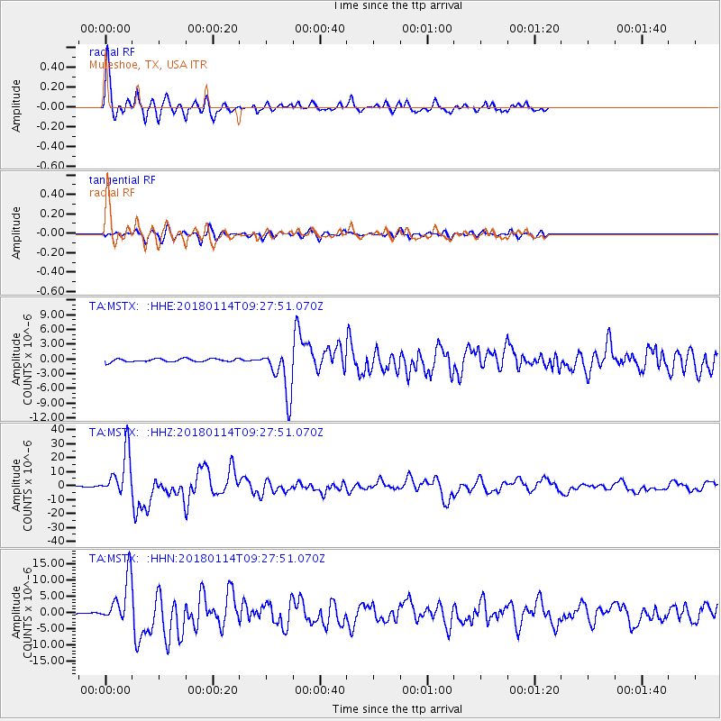
Signal To Noise
| Channel | StoN | STA | LTA |
| TA:MSTX: :HHZ:20180114T09:27:51.070Z | 75.950485 | 1.6105274E-5 | 2.1204966E-7 |
| TA:MSTX: :HHN:20180114T09:27:51.070Z | 30.53547 | 7.1768127E-6 | 2.35032E-7 |
| TA:MSTX: :HHE:20180114T09:27:51.070Z | 14.647159 | 4.716497E-6 | 3.2200765E-7 |
| Arrivals |
| Ps | 3.9 SECOND |
| PpPs | 11 SECOND |
| PsPs/PpSs | 15 SECOND |


