You are here: Home > Network List > TA - USArray Transportable Network (new EarthScope stations) Stations List
> Station P49A Miami Univ. Ecology Research Center, OH, USA > Earthquake Result Viewer
P49A Miami Univ. Ecology Research Center, OH, USA - Earthquake Result Viewer
| Earthquake location: |
Near Coast Of Peru |
| Earthquake latitude/longitude: |
-15.8/-74.7 |
| Earthquake time(UTC): |
2018/01/14 (014) 09:18:45 GMT |
| Earthquake Depth: |
36 km |
| Earthquake Magnitude: |
7.1 mww |
| Earthquake Catalog/Contributor: |
NEIC PDE/us |
|
| Network: |
TA USArray Transportable Network (new EarthScope stations) |
| Station: |
P49A Miami Univ. Ecology Research Center, OH, USA |
| Lat/Lon: |
39.53 N/84.72 W |
| Elevation: |
272 m |
|
| Distance: |
55.8 deg |
| Az: |
350.682 deg |
| Baz: |
168.371 deg |
| Ray Param: |
0.06448586 |
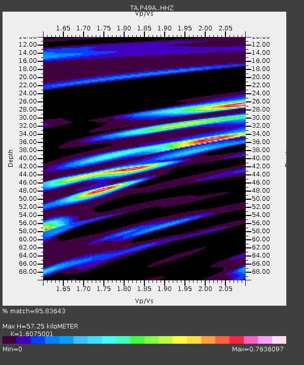
| Estimated Moho Depth: |
57.25 km |
| Estimated Crust Vp/Vs: |
1.61 |
| Assumed Crust Vp: |
6.498 km/s |
| Estimated Crust Vs: |
4.042 km/s |
| Estimated Crust Poisson's Ratio: |
0.18 |
|
| Radial Match: |
95.83643 % |
| Radial Bump: |
263 |
| Transverse Match: |
89.00593 % |
| Transverse Bump: |
400 |
| SOD ConfigId: |
13570011 |
| Insert Time: |
2019-04-29 13:44:27.209 +0000 |
| GWidth: |
2.5 |
| Max Bumps: |
400 |
| Tol: |
0.001 |
|

Signal To Noise
| Channel | StoN | STA | LTA |
| TA:P49A: :HHZ:20180114T09:27:48.039971Z | 16.866488 | 1.3859492E-5 | 8.2171783E-7 |
| TA:P49A: :HHN:20180114T09:27:48.039971Z | 16.80773 | 5.72257E-6 | 3.4047255E-7 |
| TA:P49A: :HHE:20180114T09:27:48.039971Z | 2.3620725 | 9.145917E-7 | 3.8719884E-7 |
| Arrivals |
| Ps | 5.7 SECOND |
| PpPs | 22 SECOND |
| PsPs/PpSs | 27 SECOND |


