You are here: Home > Network List > TA - USArray Transportable Network (new EarthScope stations) Stations List
> Station Q32M Nakina River, BC, CAN > Earthquake Result Viewer
Q32M Nakina River, BC, CAN - Earthquake Result Viewer
| Earthquake location: |
Near Coast Of Peru |
| Earthquake latitude/longitude: |
-15.8/-74.7 |
| Earthquake time(UTC): |
2018/01/14 (014) 09:18:45 GMT |
| Earthquake Depth: |
36 km |
| Earthquake Magnitude: |
7.1 mww |
| Earthquake Catalog/Contributor: |
NEIC PDE/us |
|
| Network: |
TA USArray Transportable Network (new EarthScope stations) |
| Station: |
Q32M Nakina River, BC, CAN |
| Lat/Lon: |
58.96 N/132.27 W |
| Elevation: |
1951 m |
|
| Distance: |
87.9 deg |
| Az: |
334.059 deg |
| Baz: |
125.63 deg |
| Ray Param: |
0.0429432 |
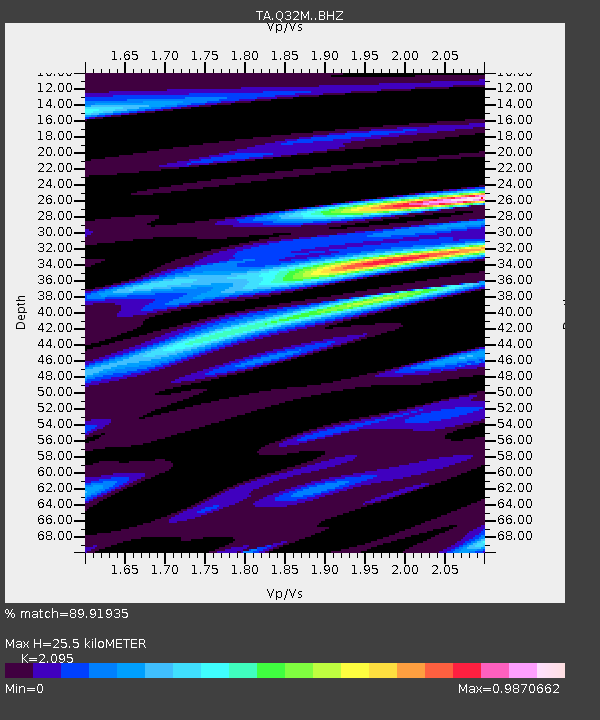
| Estimated Moho Depth: |
25.5 km |
| Estimated Crust Vp/Vs: |
2.10 |
| Assumed Crust Vp: |
6.597 km/s |
| Estimated Crust Vs: |
3.149 km/s |
| Estimated Crust Poisson's Ratio: |
0.35 |
|
| Radial Match: |
89.91935 % |
| Radial Bump: |
400 |
| Transverse Match: |
78.612015 % |
| Transverse Bump: |
400 |
| SOD ConfigId: |
13570011 |
| Insert Time: |
2019-04-29 13:44:31.613 +0000 |
| GWidth: |
2.5 |
| Max Bumps: |
400 |
| Tol: |
0.001 |
|

Signal To Noise
| Channel | StoN | STA | LTA |
| TA:Q32M: :BHZ:20180114T09:30:59.825005Z | 4.2882166 | 4.50224E-6 | 1.0499095E-6 |
| TA:Q32M: :BHN:20180114T09:30:59.825005Z | 2.3297036 | 1.0315656E-6 | 4.4278832E-7 |
| TA:Q32M: :BHE:20180114T09:30:59.825005Z | 1.4065292 | 1.6939118E-6 | 1.2043204E-6 |
| Arrivals |
| Ps | 4.3 SECOND |
| PpPs | 12 SECOND |
| PsPs/PpSs | 16 SECOND |


