You are here: Home > Network List > TA - USArray Transportable Network (new EarthScope stations) Stations List
> Station TIGA Tifton, GA, USA > Earthquake Result Viewer
TIGA Tifton, GA, USA - Earthquake Result Viewer
| Earthquake location: |
Near Coast Of Peru |
| Earthquake latitude/longitude: |
-15.8/-74.7 |
| Earthquake time(UTC): |
2018/01/14 (014) 09:18:45 GMT |
| Earthquake Depth: |
36 km |
| Earthquake Magnitude: |
7.1 mww |
| Earthquake Catalog/Contributor: |
NEIC PDE/us |
|
| Network: |
TA USArray Transportable Network (new EarthScope stations) |
| Station: |
TIGA Tifton, GA, USA |
| Lat/Lon: |
31.44 N/83.59 W |
| Elevation: |
109 m |
|
| Distance: |
47.7 deg |
| Az: |
349.765 deg |
| Baz: |
168.454 deg |
| Ray Param: |
0.06974616 |
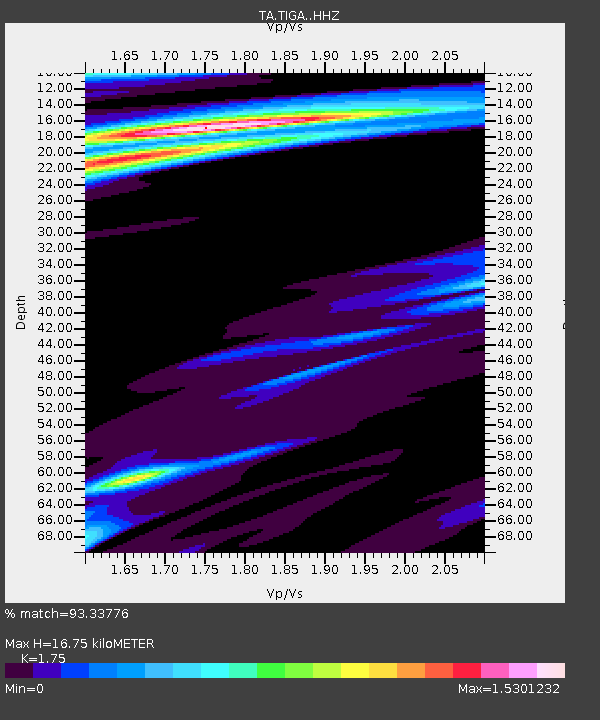
| Estimated Moho Depth: |
16.75 km |
| Estimated Crust Vp/Vs: |
1.75 |
| Assumed Crust Vp: |
6.565 km/s |
| Estimated Crust Vs: |
3.751 km/s |
| Estimated Crust Poisson's Ratio: |
0.26 |
|
| Radial Match: |
93.33776 % |
| Radial Bump: |
266 |
| Transverse Match: |
81.683876 % |
| Transverse Bump: |
272 |
| SOD ConfigId: |
13570011 |
| Insert Time: |
2019-04-29 13:44:40.540 +0000 |
| GWidth: |
2.5 |
| Max Bumps: |
400 |
| Tol: |
0.001 |
|

Signal To Noise
| Channel | StoN | STA | LTA |
| TA:TIGA: :HHZ:20180114T09:26:47.760002Z | 14.264529 | 1.9137142E-5 | 1.3415895E-6 |
| TA:TIGA: :HHN:20180114T09:26:47.760002Z | 12.010013 | 7.765437E-6 | 6.4658025E-7 |
| TA:TIGA: :HHE:20180114T09:26:47.760002Z | 1.214587 | 2.0107561E-6 | 1.655506E-6 |
| Arrivals |
| Ps | 2.0 SECOND |
| PpPs | 6.6 SECOND |
| PsPs/PpSs | 8.6 SECOND |


