You are here: Home > Network List > UO - University of Oregon Regional Network Stations List
> Station WOOD Lake of the Woods, OR, USA > Earthquake Result Viewer
WOOD Lake of the Woods, OR, USA - Earthquake Result Viewer
| Earthquake location: |
Near Coast Of Peru |
| Earthquake latitude/longitude: |
-15.8/-74.7 |
| Earthquake time(UTC): |
2018/01/14 (014) 09:18:45 GMT |
| Earthquake Depth: |
36 km |
| Earthquake Magnitude: |
7.1 mww |
| Earthquake Catalog/Contributor: |
NEIC PDE/us |
|
| Network: |
UO University of Oregon Regional Network |
| Station: |
WOOD Lake of the Woods, OR, USA |
| Lat/Lon: |
42.22 N/122.30 W |
| Elevation: |
1437 m |
|
| Distance: |
72.4 deg |
| Az: |
324.9 deg |
| Baz: |
131.817 deg |
| Ray Param: |
0.05360427 |
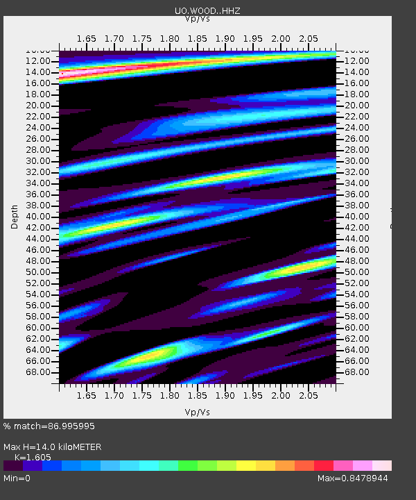
| Estimated Moho Depth: |
14.0 km |
| Estimated Crust Vp/Vs: |
1.61 |
| Assumed Crust Vp: |
6.522 km/s |
| Estimated Crust Vs: |
4.063 km/s |
| Estimated Crust Poisson's Ratio: |
0.18 |
|
| Radial Match: |
86.995995 % |
| Radial Bump: |
400 |
| Transverse Match: |
66.47865 % |
| Transverse Bump: |
400 |
| SOD ConfigId: |
13570011 |
| Insert Time: |
2019-04-29 13:45:12.292 +0000 |
| GWidth: |
2.5 |
| Max Bumps: |
400 |
| Tol: |
0.001 |
|

Signal To Noise
| Channel | StoN | STA | LTA |
| UO:WOOD: :HHZ:20180114T09:29:36.98803Z | 20.38669 | 6.947724E-6 | 3.4079707E-7 |
| UO:WOOD: :HHN:20180114T09:29:36.98803Z | 1.8268518 | 1.564948E-6 | 8.566365E-7 |
| UO:WOOD: :HHE:20180114T09:29:36.98803Z | 2.7224863 | 1.1447821E-6 | 4.2049143E-7 |
| Arrivals |
| Ps | 1.4 SECOND |
| PpPs | 5.4 SECOND |
| PsPs/PpSs | 6.7 SECOND |


