You are here: Home > Network List > UW - Pacific Northwest Regional Seismic Network Stations List
> Station GBB GBB, Hanford, WA, USA > Earthquake Result Viewer
GBB GBB, Hanford, WA, USA - Earthquake Result Viewer
| Earthquake location: |
Near Coast Of Peru |
| Earthquake latitude/longitude: |
-15.8/-74.7 |
| Earthquake time(UTC): |
2018/01/14 (014) 09:18:45 GMT |
| Earthquake Depth: |
36 km |
| Earthquake Magnitude: |
7.1 mww |
| Earthquake Catalog/Contributor: |
NEIC PDE/us |
|
| Network: |
UW Pacific Northwest Regional Seismic Network |
| Station: |
GBB GBB, Hanford, WA, USA |
| Lat/Lon: |
46.61 N/119.63 W |
| Elevation: |
185 m |
|
| Distance: |
74.1 deg |
| Az: |
329.605 deg |
| Baz: |
135.041 deg |
| Ray Param: |
0.05252946 |
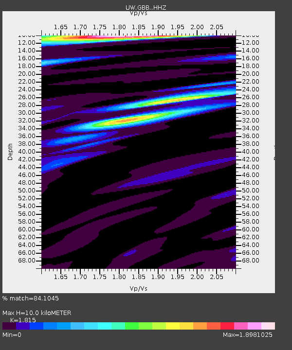
| Estimated Moho Depth: |
10.0 km |
| Estimated Crust Vp/Vs: |
1.82 |
| Assumed Crust Vp: |
6.419 km/s |
| Estimated Crust Vs: |
3.537 km/s |
| Estimated Crust Poisson's Ratio: |
0.28 |
|
| Radial Match: |
84.1045 % |
| Radial Bump: |
400 |
| Transverse Match: |
81.788765 % |
| Transverse Bump: |
400 |
| SOD ConfigId: |
13570011 |
| Insert Time: |
2019-04-29 13:45:33.244 +0000 |
| GWidth: |
2.5 |
| Max Bumps: |
400 |
| Tol: |
0.001 |
|

Signal To Noise
| Channel | StoN | STA | LTA |
| UW:GBB: :HHZ:20180114T09:29:46.530022Z | 16.375305 | 4.1287503E-6 | 2.521327E-7 |
| UW:GBB: :HHN:20180114T09:29:46.530022Z | 5.573157 | 9.125465E-7 | 1.637396E-7 |
| UW:GBB: :HHE:20180114T09:29:46.530022Z | 4.6166406 | 1.0474286E-6 | 2.268811E-7 |
| Arrivals |
| Ps | 1.3 SECOND |
| PpPs | 4.2 SECOND |
| PsPs/PpSs | 5.6 SECOND |


