You are here: Home > Network List > UW - Pacific Northwest Regional Seismic Network Stations List
> Station STOR Enumclaw, WA, USA > Earthquake Result Viewer
STOR Enumclaw, WA, USA - Earthquake Result Viewer
| Earthquake location: |
Near Coast Of Peru |
| Earthquake latitude/longitude: |
-15.8/-74.7 |
| Earthquake time(UTC): |
2018/01/14 (014) 09:18:45 GMT |
| Earthquake Depth: |
36 km |
| Earthquake Magnitude: |
7.1 mww |
| Earthquake Catalog/Contributor: |
NEIC PDE/us |
|
| Network: |
UW Pacific Northwest Regional Seismic Network |
| Station: |
STOR Enumclaw, WA, USA |
| Lat/Lon: |
47.19 N/121.99 W |
| Elevation: |
266 m |
|
| Distance: |
75.6 deg |
| Az: |
328.87 deg |
| Baz: |
133.131 deg |
| Ray Param: |
0.051485162 |
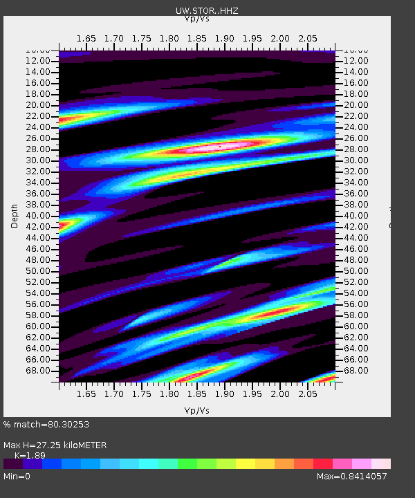
| Estimated Moho Depth: |
27.25 km |
| Estimated Crust Vp/Vs: |
1.89 |
| Assumed Crust Vp: |
6.597 km/s |
| Estimated Crust Vs: |
3.491 km/s |
| Estimated Crust Poisson's Ratio: |
0.31 |
|
| Radial Match: |
80.30253 % |
| Radial Bump: |
400 |
| Transverse Match: |
76.19161 % |
| Transverse Bump: |
400 |
| SOD ConfigId: |
13570011 |
| Insert Time: |
2019-04-29 13:45:56.865 +0000 |
| GWidth: |
2.5 |
| Max Bumps: |
400 |
| Tol: |
0.001 |
|

Signal To Noise
| Channel | StoN | STA | LTA |
| UW:STOR: :HHZ:20180114T09:29:55.557976Z | 9.778798 | 5.5797723E-6 | 5.7059896E-7 |
| UW:STOR: :HHN:20180114T09:29:55.557976Z | 2.8740013 | 1.5035318E-6 | 5.231493E-7 |
| UW:STOR: :HHE:20180114T09:29:55.557976Z | 5.149026 | 1.4945958E-6 | 2.9026768E-7 |
| Arrivals |
| Ps | 3.8 SECOND |
| PpPs | 12 SECOND |
| PsPs/PpSs | 15 SECOND |


