You are here: Home > Network List > UW - Pacific Northwest Regional Seismic Network Stations List
> Station UMAT Pilot Rock, OR, USA > Earthquake Result Viewer
UMAT Pilot Rock, OR, USA - Earthquake Result Viewer
| Earthquake location: |
Near Coast Of Peru |
| Earthquake latitude/longitude: |
-15.8/-74.7 |
| Earthquake time(UTC): |
2018/01/14 (014) 09:18:45 GMT |
| Earthquake Depth: |
36 km |
| Earthquake Magnitude: |
7.1 mww |
| Earthquake Catalog/Contributor: |
NEIC PDE/us |
|
| Network: |
UW Pacific Northwest Regional Seismic Network |
| Station: |
UMAT Pilot Rock, OR, USA |
| Lat/Lon: |
45.29 N/118.96 W |
| Elevation: |
1318 m |
|
| Distance: |
72.8 deg |
| Az: |
328.982 deg |
| Baz: |
135.343 deg |
| Ray Param: |
0.053368136 |
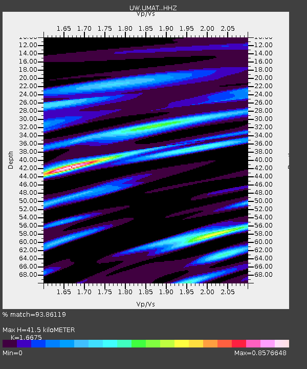
| Estimated Moho Depth: |
41.5 km |
| Estimated Crust Vp/Vs: |
1.67 |
| Assumed Crust Vp: |
6.571 km/s |
| Estimated Crust Vs: |
3.94 km/s |
| Estimated Crust Poisson's Ratio: |
0.22 |
|
| Radial Match: |
93.86119 % |
| Radial Bump: |
400 |
| Transverse Match: |
77.46997 % |
| Transverse Bump: |
400 |
| SOD ConfigId: |
13570011 |
| Insert Time: |
2019-04-29 13:46:01.070 +0000 |
| GWidth: |
2.5 |
| Max Bumps: |
400 |
| Tol: |
0.001 |
|

Signal To Noise
| Channel | StoN | STA | LTA |
| UW:UMAT: :HHZ:20180114T09:29:39.117974Z | 12.268379 | 3.857072E-6 | 3.1439131E-7 |
| UW:UMAT: :HHN:20180114T09:29:39.117974Z | 3.8682356 | 1.0742439E-6 | 2.77709E-7 |
| UW:UMAT: :HHE:20180114T09:29:39.117974Z | 5.1048093 | 1.204429E-6 | 2.3594008E-7 |
| Arrivals |
| Ps | 4.4 SECOND |
| PpPs | 16 SECOND |
| PsPs/PpSs | 21 SECOND |


