You are here: Home > Network List > NM - Cooperative New Madrid Seismic Network Stations List
> Station HBAR Harrisburg,AR(CERI) > Earthquake Result Viewer
HBAR Harrisburg,AR(CERI) - Earthquake Result Viewer
| Earthquake location: |
Near Coast Of Ecuador |
| Earthquake latitude/longitude: |
0.4/-79.9 |
| Earthquake time(UTC): |
2016/04/16 (107) 23:58:37 GMT |
| Earthquake Depth: |
19 km |
| Earthquake Magnitude: |
7.8 MWW, 7.4 MI |
| Earthquake Catalog/Contributor: |
NEIC PDE/NEIC COMCAT |
|
| Network: |
NM Cooperative New Madrid Seismic Network |
| Station: |
HBAR Harrisburg,AR(CERI) |
| Lat/Lon: |
35.56 N/90.66 W |
| Elevation: |
74 m |
|
| Distance: |
36.4 deg |
| Az: |
345.196 deg |
| Baz: |
161.738 deg |
| Ray Param: |
0.07667854 |
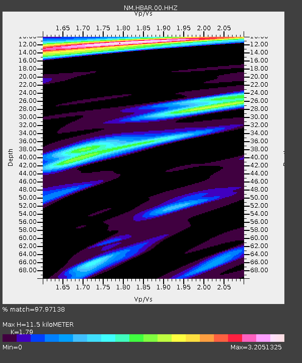
| Estimated Moho Depth: |
11.5 km |
| Estimated Crust Vp/Vs: |
1.79 |
| Assumed Crust Vp: |
6.273 km/s |
| Estimated Crust Vs: |
3.505 km/s |
| Estimated Crust Poisson's Ratio: |
0.27 |
|
| Radial Match: |
97.97138 % |
| Radial Bump: |
297 |
| Transverse Match: |
83.40644 % |
| Transverse Bump: |
400 |
| SOD ConfigId: |
1475611 |
| Insert Time: |
2016-05-01 00:12:06.571 +0000 |
| GWidth: |
2.5 |
| Max Bumps: |
400 |
| Tol: |
0.001 |
|

Signal To Noise
| Channel | StoN | STA | LTA |
| NM:HBAR:00:HHZ:20160417T00:05:09.655Z | 26.20184 | 6.9216962E-6 | 2.641683E-7 |
| NM:HBAR:00:HHN:20160417T00:05:09.655Z | 5.4925103 | 4.813212E-6 | 8.763228E-7 |
| NM:HBAR:00:HHE:20160417T00:05:09.655Z | 4.983252 | 2.2211796E-6 | 4.4572892E-7 |
| Arrivals |
| Ps | 1.6 SECOND |
| PpPs | 4.8 SECOND |
| PsPs/PpSs | 6.3 SECOND |


