You are here: Home > Network List > NM - Cooperative New Madrid Seismic Network Stations List
> Station HENM Henderson Mound,MO > Earthquake Result Viewer
HENM Henderson Mound,MO - Earthquake Result Viewer
| Earthquake location: |
Near Coast Of Ecuador |
| Earthquake latitude/longitude: |
0.4/-79.9 |
| Earthquake time(UTC): |
2016/04/16 (107) 23:58:37 GMT |
| Earthquake Depth: |
19 km |
| Earthquake Magnitude: |
7.8 MWW, 7.4 MI |
| Earthquake Catalog/Contributor: |
NEIC PDE/NEIC COMCAT |
|
| Network: |
NM Cooperative New Madrid Seismic Network |
| Station: |
HENM Henderson Mound,MO |
| Lat/Lon: |
36.72 N/89.47 W |
| Elevation: |
88 m |
|
| Distance: |
37.2 deg |
| Az: |
347.294 deg |
| Baz: |
164.114 deg |
| Ray Param: |
0.07622875 |
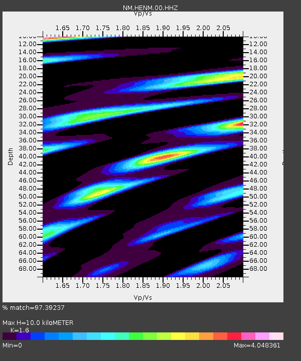
| Estimated Moho Depth: |
10.0 km |
| Estimated Crust Vp/Vs: |
1.60 |
| Assumed Crust Vp: |
6.444 km/s |
| Estimated Crust Vs: |
4.027 km/s |
| Estimated Crust Poisson's Ratio: |
0.18 |
|
| Radial Match: |
97.39237 % |
| Radial Bump: |
322 |
| Transverse Match: |
90.465096 % |
| Transverse Bump: |
380 |
| SOD ConfigId: |
1475611 |
| Insert Time: |
2016-05-01 00:12:23.475 +0000 |
| GWidth: |
2.5 |
| Max Bumps: |
400 |
| Tol: |
0.001 |
|

Signal To Noise
| Channel | StoN | STA | LTA |
| NM:HENM:00:HHZ:20160417T00:05:16.684999Z | 9.253522 | 7.1448953E-6 | 7.7212707E-7 |
| NM:HENM:00:HHN:20160417T00:05:16.684999Z | 3.0991962 | 5.915503E-6 | 1.9087217E-6 |
| NM:HENM:00:HHE:20160417T00:05:16.684999Z | 2.5558743 | 2.6965547E-6 | 1.0550419E-6 |
| Arrivals |
| Ps | 1.0 SECOND |
| PpPs | 3.7 SECOND |
| PsPs/PpSs | 4.7 SECOND |


